You are here: Home > Network List > US - United States National Seismic Network Stations List
> Station GLMI Grayling, Michigan, USA > Earthquake Result Viewer
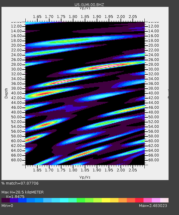
GLMI Grayling, Michigan, USA - Earthquake Result Viewer
| Earthquake location: |
Near East Coast Of Honshu, Japan |
| Earthquake latitude/longitude: |
37.7/141.8 |
| Earthquake time(UTC): |
2021/05/13 (133) 23:58:14 GMT |
| Earthquake Depth: |
32 km |
| Earthquake Magnitude: |
6.0 mww |
| Earthquake Catalog/Contributor: |
NEIC PDE/us |
|
| Network: |
US United States National Seismic Network |
| Station: |
GLMI Grayling, Michigan, USA |
| Lat/Lon: |
44.82 N/84.62 W |
| Elevation: |
387 m |
|
| Distance: |
87.8 deg |
| Az: |
31.044 deg |
| Baz: |
324.918 deg |
| Ray Param: |
0.04303305 |
| Estimated Moho Depth: |
28.5 km |
| Estimated Crust Vp/Vs: |
1.95 |
| Assumed Crust Vp: |
6.483 km/s |
| Estimated Crust Vs: |
3.329 km/s |
| Estimated Crust Poisson's Ratio: |
0.32 |
|
| Radial Match: |
87.87706 % |
| Radial Bump: |
400 |
| Transverse Match: |
77.57359 % |
| Transverse Bump: |
400 |
| SOD ConfigId: |
24890451 |
| Insert Time: |
2021-06-02 16:50:49.544 +0000 |
| GWidth: |
2.5 |
| Max Bumps: |
400 |
| Tol: |
0.001 |
|

Signal To Noise
| Channel | StoN | STA | LTA |
| US:GLMI:00:BHZ:20210514T00:10:28.64998Z | 9.157979 | 1.7145427E-6 | 1.8721846E-7 |
| US:GLMI:00:BH1:20210514T00:10:28.64998Z | 3.0528262 | 1.024043E-6 | 3.3544094E-7 |
| US:GLMI:00:BH2:20210514T00:10:28.64998Z | 1.9911343 | 5.997455E-7 | 3.0120796E-7 |
| Arrivals |
| Ps | 4.3 SECOND |
| PpPs | 13 SECOND |
| PsPs/PpSs | 17 SECOND |


