You are here: Home > Network List > XH94 - Colorado Plateau-Great Basin Network Stations List
> Station SRS San Rafael Swell, Utah > Earthquake Result Viewer
SRS San Rafael Swell, Utah - Earthquake Result Viewer
| Earthquake location: |
Kuril Islands |
| Earthquake latitude/longitude: |
48.8/154.5 |
| Earthquake time(UTC): |
1995/06/29 (180) 07:45:09 GMT |
| Earthquake Depth: |
62 km |
| Earthquake Magnitude: |
5.9 MB, 6.0 UNKNOWN, 6.0 MW |
| Earthquake Catalog/Contributor: |
WHDF/NEIC |
|
| Network: |
XH Colorado Plateau-Great Basin Network |
| Station: |
SRS San Rafael Swell, Utah |
| Lat/Lon: |
38.91 N/110.60 W |
| Elevation: |
2019 m |
|
| Distance: |
64.9 deg |
| Az: |
59.157 deg |
| Baz: |
313.291 deg |
| Ray Param: |
0.058504473 |
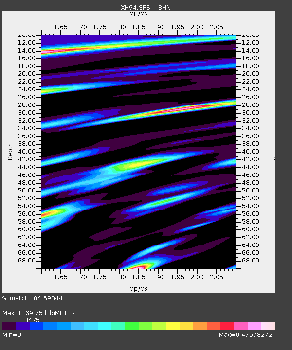
| Estimated Moho Depth: |
69.75 km |
| Estimated Crust Vp/Vs: |
1.85 |
| Assumed Crust Vp: |
6.207 km/s |
| Estimated Crust Vs: |
3.36 km/s |
| Estimated Crust Poisson's Ratio: |
0.29 |
|
| Radial Match: |
84.59344 % |
| Radial Bump: |
383 |
| Transverse Match: |
80.7662 % |
| Transverse Bump: |
389 |
| SOD ConfigId: |
6273 |
| Insert Time: |
2010-03-09 08:21:46.135 +0000 |
| GWidth: |
2.5 |
| Max Bumps: |
400 |
| Tol: |
0.001 |
|

Signal To Noise
| Channel | StoN | STA | LTA |
| XH:SRS: :BHN:19950629T07:55:11.548022Z | 10.386522 | 3.307893E-7 | 3.1847936E-8 |
| XH:SRS: :BHE:19950629T07:55:11.548022Z | 5.304145 | 3.029994E-7 | 5.7125025E-8 |
| XH:SRS: :BHZ:19950629T07:55:11.548022Z | 19.418276 | 1.4689165E-6 | 7.564608E-8 |
| Arrivals |
| Ps | 9.9 SECOND |
| PpPs | 31 SECOND |
| PsPs/PpSs | 41 SECOND |


