You are here: Home > Network List > UW - Pacific Northwest Regional Seismic Network Stations List
> Station LNO Lincton Mt., Oregon previous ISC code: LNOR > Earthquake Result Viewer
LNO Lincton Mt., Oregon previous ISC code: LNOR - Earthquake Result Viewer
| Earthquake location: |
Near East Coast Of Honshu, Japan |
| Earthquake latitude/longitude: |
37.7/141.8 |
| Earthquake time(UTC): |
2021/05/13 (133) 23:58:14 GMT |
| Earthquake Depth: |
32 km |
| Earthquake Magnitude: |
6.0 mww |
| Earthquake Catalog/Contributor: |
NEIC PDE/us |
|
| Network: |
UW Pacific Northwest Regional Seismic Network |
| Station: |
LNO Lincton Mt., Oregon previous ISC code: LNOR |
| Lat/Lon: |
45.87 N/118.29 W |
| Elevation: |
771 m |
|
| Distance: |
70.1 deg |
| Az: |
47.04 deg |
| Baz: |
303.822 deg |
| Ray Param: |
0.055166513 |
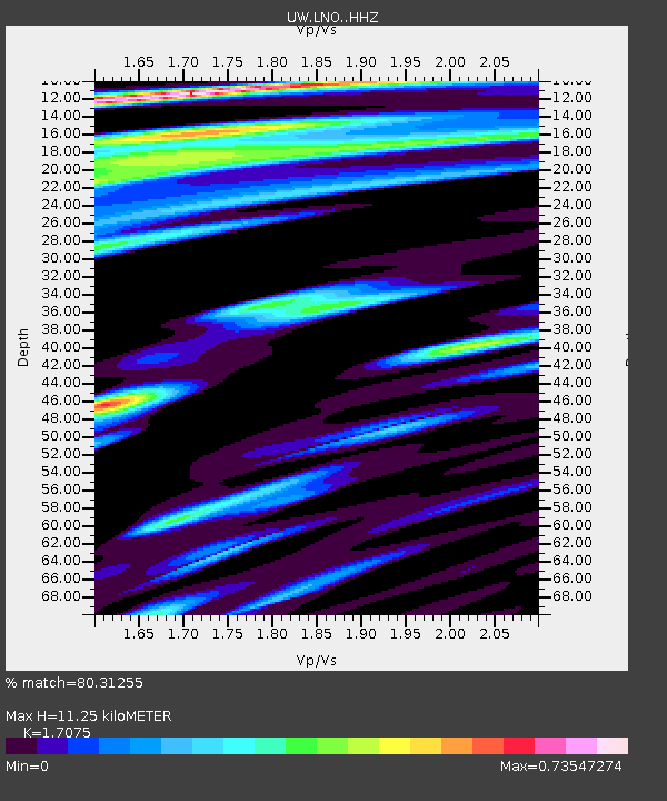
| Estimated Moho Depth: |
11.25 km |
| Estimated Crust Vp/Vs: |
1.71 |
| Assumed Crust Vp: |
6.571 km/s |
| Estimated Crust Vs: |
3.848 km/s |
| Estimated Crust Poisson's Ratio: |
0.24 |
|
| Radial Match: |
80.31255 % |
| Radial Bump: |
400 |
| Transverse Match: |
58.618366 % |
| Transverse Bump: |
400 |
| SOD ConfigId: |
24890451 |
| Insert Time: |
2021-06-02 16:53:00.075 +0000 |
| GWidth: |
2.5 |
| Max Bumps: |
400 |
| Tol: |
0.001 |
|

Signal To Noise
| Channel | StoN | STA | LTA |
| UW:LNO: :HHZ:20210514T00:08:52.240007Z | 8.4082775 | 7.0849546E-7 | 8.4261664E-8 |
| UW:LNO: :HHN:20210514T00:08:52.240007Z | 2.3061585 | 1.5386718E-7 | 6.672012E-8 |
| UW:LNO: :HHE:20210514T00:08:52.240007Z | 2.6658998 | 2.1215902E-7 | 7.958252E-8 |
| Arrivals |
| Ps | 1.3 SECOND |
| PpPs | 4.5 SECOND |
| PsPs/PpSs | 5.7 SECOND |


