You are here: Home > Network List > XH94 - Colorado Plateau-Great Basin Network Stations List
> Station SRS San Rafael Swell, Utah > Earthquake Result Viewer
SRS San Rafael Swell, Utah - Earthquake Result Viewer
| Earthquake location: |
Leeward Islands |
| Earthquake latitude/longitude: |
16.6/-59.6 |
| Earthquake time(UTC): |
1995/03/08 (067) 03:45:59 GMT |
| Earthquake Depth: |
15 km |
| Earthquake Magnitude: |
6.3 MB, 6.2 MS, 6.4 UNKNOWN, 6.1 MD |
| Earthquake Catalog/Contributor: |
WHDF/NEIC |
|
| Network: |
XH Colorado Plateau-Great Basin Network |
| Station: |
SRS San Rafael Swell, Utah |
| Lat/Lon: |
38.91 N/110.60 W |
| Elevation: |
2019 m |
|
| Distance: |
49.6 deg |
| Az: |
307.238 deg |
| Baz: |
101.848 deg |
| Ray Param: |
0.068567075 |
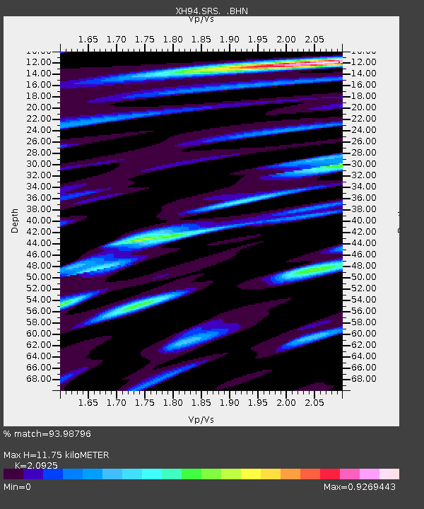
| Estimated Moho Depth: |
11.75 km |
| Estimated Crust Vp/Vs: |
2.09 |
| Assumed Crust Vp: |
6.207 km/s |
| Estimated Crust Vs: |
2.966 km/s |
| Estimated Crust Poisson's Ratio: |
0.35 |
|
| Radial Match: |
93.98796 % |
| Radial Bump: |
311 |
| Transverse Match: |
75.81573 % |
| Transverse Bump: |
400 |
| SOD ConfigId: |
6273 |
| Insert Time: |
2010-03-09 08:21:53.308 +0000 |
| GWidth: |
2.5 |
| Max Bumps: |
400 |
| Tol: |
0.001 |
|

Signal To Noise
| Channel | StoN | STA | LTA |
| XH:SRS: :BHN:19950308T03:54:19.494006Z | 0.6258663 | 5.813256E-8 | 9.288335E-8 |
| XH:SRS: :BHE:19950308T03:54:19.494006Z | 2.291111 | 2.7444815E-7 | 1.1978824E-7 |
| XH:SRS: :BHZ:19950308T03:54:19.494006Z | 3.9756203 | 7.0874256E-7 | 1.782722E-7 |
| Arrivals |
| Ps | 2.2 SECOND |
| PpPs | 5.6 SECOND |
| PsPs/PpSs | 7.8 SECOND |


