You are here: Home > Network List > IW - Intermountain West Stations List
> Station MOOW Moose Ponds, Wyoming, USA > Earthquake Result Viewer
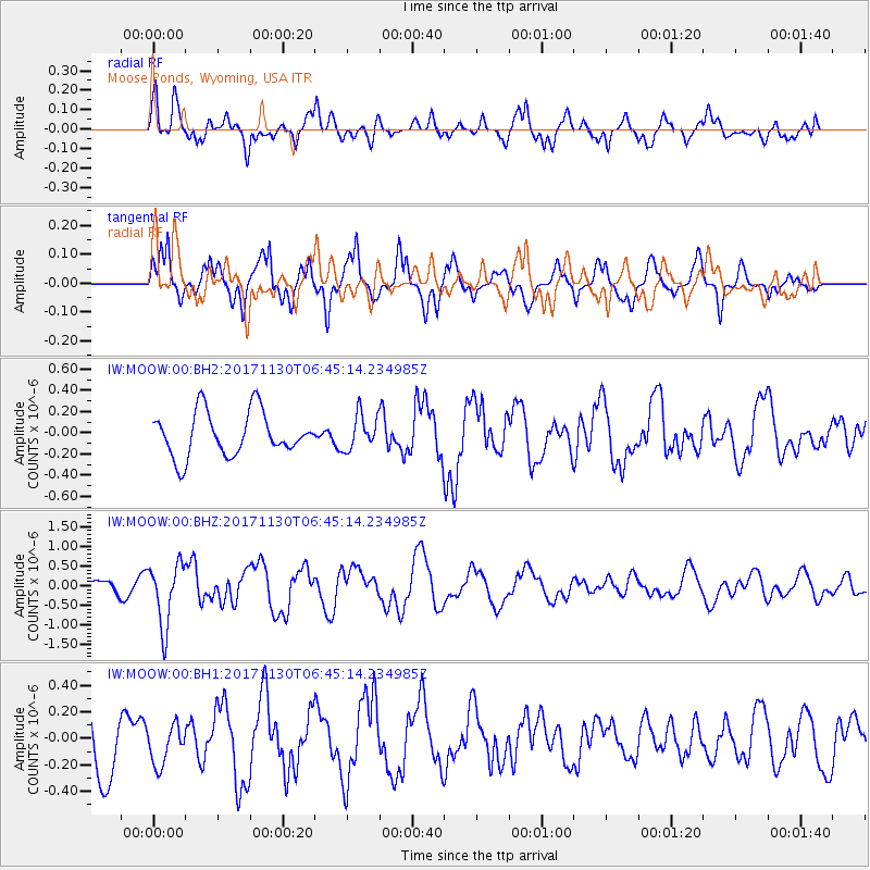
MOOW Moose Ponds, Wyoming, USA - Earthquake Result Viewer
*The percent match for this event was below the threshold and hence no stack was calculated.
| Earthquake location: |
Central Mid-Atlantic Ridge |
| Earthquake latitude/longitude: |
-1.1/-23.5 |
| Earthquake time(UTC): |
2017/11/30 (334) 06:32:52 GMT |
| Earthquake Depth: |
10 km |
| Earthquake Magnitude: |
6.5 Mi |
| Earthquake Catalog/Contributor: |
NEIC PDE/at |
|
| Network: |
IW Intermountain West |
| Station: |
MOOW Moose Ponds, Wyoming, USA |
| Lat/Lon: |
43.75 N/110.74 W |
| Elevation: |
2128 m |
|
| Distance: |
88.8 deg |
| Az: |
313.612 deg |
| Baz: |
92.691 deg |
| Ray Param: |
$rayparam |
*The percent match for this event was below the threshold and hence was not used in the summary stack. |
|
| Radial Match: |
68.43795 % |
| Radial Bump: |
400 |
| Transverse Match: |
55.04468 % |
| Transverse Bump: |
400 |
| SOD ConfigId: |
2429771 |
| Insert Time: |
2017-12-14 06:38:35.287 +0000 |
| GWidth: |
2.5 |
| Max Bumps: |
400 |
| Tol: |
0.001 |
|
Signal To Noise
| Channel | StoN | STA | LTA |
| IW:MOOW:00:BHZ:20171130T06:45:14.234985Z | 2.6307168 | 7.906126E-7 | 3.0053124E-7 |
| IW:MOOW:00:BH1:20171130T06:45:14.234985Z | 0.54927695 | 1.4677467E-7 | 2.6721432E-7 |
| IW:MOOW:00:BH2:20171130T06:45:14.234985Z | 0.7969945 | 1.652067E-7 | 2.0728713E-7 |
| Arrivals |
| Ps | |
| PpPs | |
| PsPs/PpSs | |


