You are here: Home > Network List > WY - Yellowstone Wyoming Seismic Network Stations List
> Station YHR Hawk's Rest, WY, USA > Earthquake Result Viewer
YHR Hawk's Rest, WY, USA - Earthquake Result Viewer
| Earthquake location: |
Near East Coast Of Honshu, Japan |
| Earthquake latitude/longitude: |
37.7/141.8 |
| Earthquake time(UTC): |
2021/05/13 (133) 23:58:14 GMT |
| Earthquake Depth: |
32 km |
| Earthquake Magnitude: |
6.0 mww |
| Earthquake Catalog/Contributor: |
NEIC PDE/us |
|
| Network: |
WY Yellowstone Wyoming Seismic Network |
| Station: |
YHR Hawk's Rest, WY, USA |
| Lat/Lon: |
44.11 N/110.08 W |
| Elevation: |
2976 m |
|
| Distance: |
75.8 deg |
| Az: |
44.912 deg |
| Baz: |
308.986 deg |
| Ray Param: |
0.051354345 |
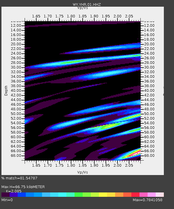
| Estimated Moho Depth: |
66.75 km |
| Estimated Crust Vp/Vs: |
2.09 |
| Assumed Crust Vp: |
6.35 km/s |
| Estimated Crust Vs: |
3.046 km/s |
| Estimated Crust Poisson's Ratio: |
0.35 |
|
| Radial Match: |
81.54787 % |
| Radial Bump: |
400 |
| Transverse Match: |
75.649216 % |
| Transverse Bump: |
400 |
| SOD ConfigId: |
24890451 |
| Insert Time: |
2021-06-02 16:54:42.909 +0000 |
| GWidth: |
2.5 |
| Max Bumps: |
400 |
| Tol: |
0.001 |
|

Signal To Noise
| Channel | StoN | STA | LTA |
| WY:YHR:01:HHZ:20210514T00:09:26.06801Z | 3.8632748 | 1.3807913E-8 | 3.5741472E-9 |
| WY:YHR:01:HHN:20210514T00:09:26.06801Z | 1.5687697 | 5.7326104E-9 | 3.6542078E-9 |
| WY:YHR:01:HHE:20210514T00:09:26.06801Z | 1.2423518 | 5.8687646E-9 | 4.7239155E-9 |
| Arrivals |
| Ps | 12 SECOND |
| PpPs | 32 SECOND |
| PsPs/PpSs | 43 SECOND |


