You are here: Home > Network List > AK - Alaska Regional Network Stations List
> Station F21K Alatna River, AK, USA > Earthquake Result Viewer
F21K Alatna River, AK, USA - Earthquake Result Viewer
| Earthquake location: |
Off W Coast Of Northern Sumatra |
| Earthquake latitude/longitude: |
0.1/96.6 |
| Earthquake time(UTC): |
2021/05/14 (134) 06:33:07 GMT |
| Earthquake Depth: |
11 km |
| Earthquake Magnitude: |
6.7 mww |
| Earthquake Catalog/Contributor: |
NEIC PDE/us |
|
| Network: |
AK Alaska Regional Network |
| Station: |
F21K Alatna River, AK, USA |
| Lat/Lon: |
67.22 N/153.48 W |
| Elevation: |
597 m |
|
| Distance: |
97.5 deg |
| Az: |
21.674 deg |
| Baz: |
288.465 deg |
| Ray Param: |
0.040203925 |
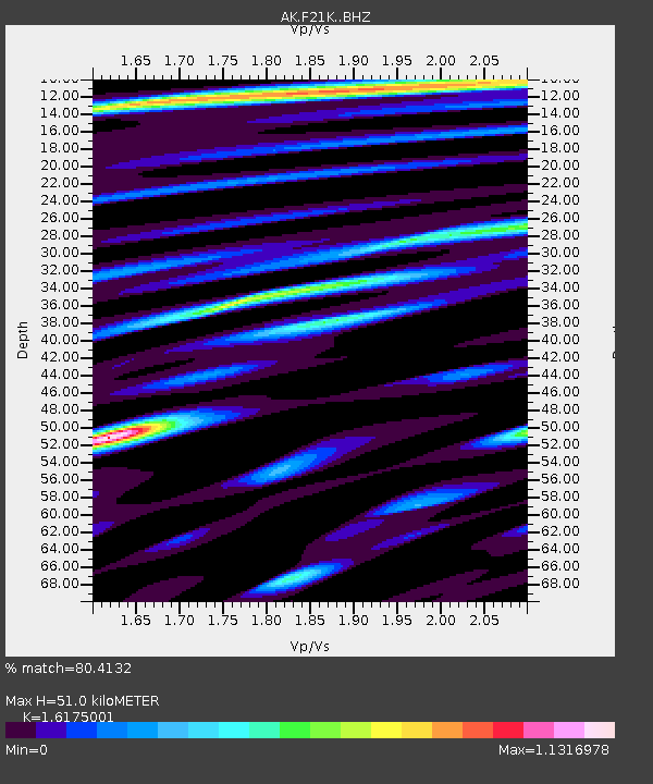
| Estimated Moho Depth: |
51.0 km |
| Estimated Crust Vp/Vs: |
1.62 |
| Assumed Crust Vp: |
6.455 km/s |
| Estimated Crust Vs: |
3.991 km/s |
| Estimated Crust Poisson's Ratio: |
0.19 |
|
| Radial Match: |
80.4132 % |
| Radial Bump: |
400 |
| Transverse Match: |
72.04713 % |
| Transverse Bump: |
400 |
| SOD ConfigId: |
24890451 |
| Insert Time: |
2021-06-02 16:56:55.741 +0000 |
| GWidth: |
2.5 |
| Max Bumps: |
400 |
| Tol: |
0.001 |
|

Signal To Noise
| Channel | StoN | STA | LTA |
| AK:F21K: :BHZ:20210514T06:46:09.879977Z | 3.723895 | 1.6447405E-7 | 4.416721E-8 |
| AK:F21K: :BHN:20210514T06:46:09.879977Z | 1.1053648 | 6.668465E-8 | 6.032818E-8 |
| AK:F21K: :BHE:20210514T06:46:09.879977Z | 1.2137889 | 6.8441615E-8 | 5.6386753E-8 |
| Arrivals |
| Ps | 5.0 SECOND |
| PpPs | 20 SECOND |
| PsPs/PpSs | 25 SECOND |


