You are here: Home > Network List > BX - Botswana Seismological Network Stations List
> Station BROLN Borolong > Earthquake Result Viewer
BROLN Borolong - Earthquake Result Viewer
| Earthquake location: |
Off W Coast Of Northern Sumatra |
| Earthquake latitude/longitude: |
0.1/96.6 |
| Earthquake time(UTC): |
2021/05/14 (134) 06:33:07 GMT |
| Earthquake Depth: |
11 km |
| Earthquake Magnitude: |
6.7 mww |
| Earthquake Catalog/Contributor: |
NEIC PDE/us |
|
| Network: |
BX Botswana Seismological Network |
| Station: |
BROLN Borolong |
| Lat/Lon: |
21.10 S/27.33 E |
| Elevation: |
1047 m |
|
| Distance: |
70.8 deg |
| Az: |
247.677 deg |
| Baz: |
82.17 deg |
| Ray Param: |
0.054759186 |
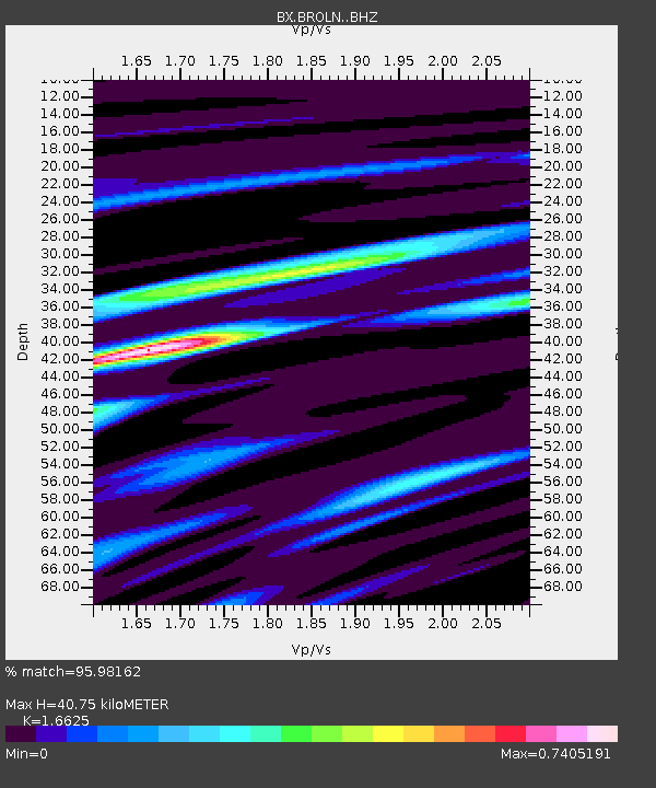
| Estimated Moho Depth: |
40.75 km |
| Estimated Crust Vp/Vs: |
1.66 |
| Assumed Crust Vp: |
6.459 km/s |
| Estimated Crust Vs: |
3.885 km/s |
| Estimated Crust Poisson's Ratio: |
0.22 |
|
| Radial Match: |
95.98162 % |
| Radial Bump: |
334 |
| Transverse Match: |
85.738754 % |
| Transverse Bump: |
400 |
| SOD ConfigId: |
24890451 |
| Insert Time: |
2021-06-02 16:58:26.209 +0000 |
| GWidth: |
2.5 |
| Max Bumps: |
400 |
| Tol: |
0.001 |
|

Signal To Noise
| Channel | StoN | STA | LTA |
| BX:BROLN: :BHZ:20210514T06:43:52.951998Z | 3.5639217 | 7.904392E-7 | 2.2178914E-7 |
| BX:BROLN: :BHN:20210514T06:43:52.951998Z | 1.6125996 | 2.3015224E-7 | 1.4272125E-7 |
| BX:BROLN: :BHE:20210514T06:43:52.951998Z | 2.1277568 | 3.4082308E-7 | 1.6017952E-7 |
| Arrivals |
| Ps | 4.3 SECOND |
| PpPs | 16 SECOND |
| PsPs/PpSs | 20 SECOND |


