You are here: Home > Network List > G - GEOSCOPE Stations List
> Station ATD Arta Cave - Arta, Republic of Djibouti > Earthquake Result Viewer
ATD Arta Cave - Arta, Republic of Djibouti - Earthquake Result Viewer
| Earthquake location: |
Off W Coast Of Northern Sumatra |
| Earthquake latitude/longitude: |
0.1/96.6 |
| Earthquake time(UTC): |
2021/05/14 (134) 06:33:07 GMT |
| Earthquake Depth: |
11 km |
| Earthquake Magnitude: |
6.7 mww |
| Earthquake Catalog/Contributor: |
NEIC PDE/us |
|
| Network: |
G GEOSCOPE |
| Station: |
ATD Arta Cave - Arta, Republic of Djibouti |
| Lat/Lon: |
11.53 N/42.85 E |
| Elevation: |
610 m |
|
| Distance: |
54.6 deg |
| Az: |
284.004 deg |
| Baz: |
98.11 deg |
| Ray Param: |
0.06535192 |
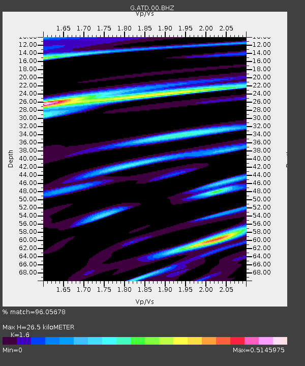
| Estimated Moho Depth: |
26.5 km |
| Estimated Crust Vp/Vs: |
1.60 |
| Assumed Crust Vp: |
6.375 km/s |
| Estimated Crust Vs: |
3.984 km/s |
| Estimated Crust Poisson's Ratio: |
0.18 |
|
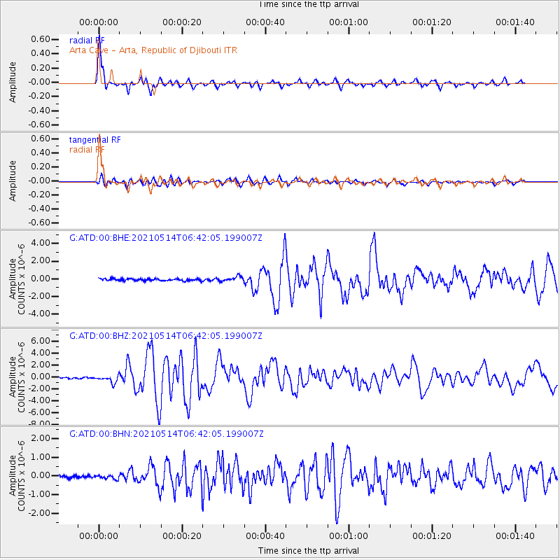
| Radial Match: |
96.05678 % |
| Radial Bump: |
385 |
| Transverse Match: |
87.54256 % |
| Transverse Bump: |
400 |
| SOD ConfigId: |
24890451 |
| Insert Time: |
2021-06-02 16:59:10.515 +0000 |
| GWidth: |
2.5 |
| Max Bumps: |
400 |
| Tol: |
0.001 |
|
Signal To Noise
| Channel | StoN | STA | LTA |
| G:ATD:00:BHZ:20210514T06:42:05.199007Z | 7.6458306 | 6.163494E-7 | 8.061248E-8 |
| G:ATD:00:BHN:20210514T06:42:05.199007Z | 1.3458126 | 1.0225548E-7 | 7.598047E-8 |
| G:ATD:00:BHE:20210514T06:42:05.199007Z | 2.4859 | 2.8187196E-7 | 1.13388296E-7 |
| Arrivals |
| Ps | 2.6 SECOND |
| PpPs | 10 SECOND |
| PsPs/PpSs | 13 SECOND |


