You are here: Home > Network List > G - GEOSCOPE Stations List
> Station SANVU Espiritu Santo, Vanuatu > Earthquake Result Viewer
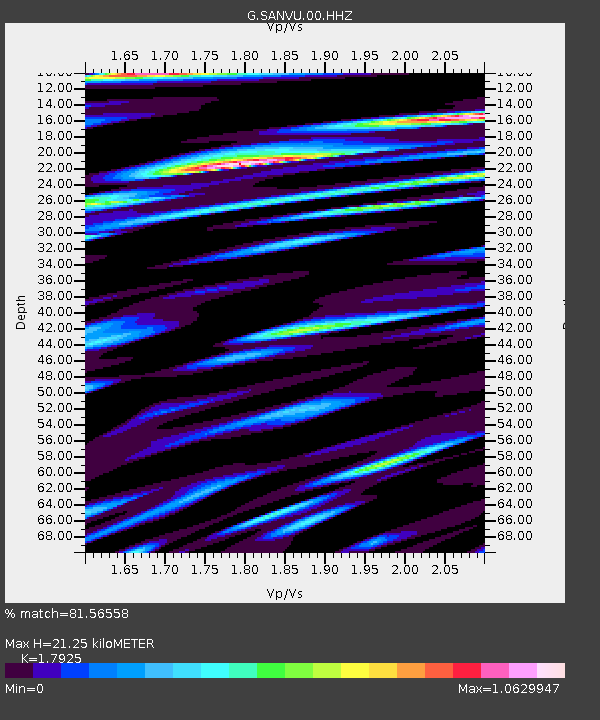
SANVU Espiritu Santo, Vanuatu - Earthquake Result Viewer
| Earthquake location: |
Off W Coast Of Northern Sumatra |
| Earthquake latitude/longitude: |
0.1/96.6 |
| Earthquake time(UTC): |
2021/05/14 (134) 06:33:07 GMT |
| Earthquake Depth: |
11 km |
| Earthquake Magnitude: |
6.7 mww |
| Earthquake Catalog/Contributor: |
NEIC PDE/us |
|
| Network: |
G GEOSCOPE |
| Station: |
SANVU Espiritu Santo, Vanuatu |
| Lat/Lon: |
15.45 S/167.20 E |
| Elevation: |
56 m |
|
| Distance: |
71.3 deg |
| Az: |
106.273 deg |
| Baz: |
275.475 deg |
| Ray Param: |
0.05441105 |
| Estimated Moho Depth: |
21.25 km |
| Estimated Crust Vp/Vs: |
1.79 |
| Assumed Crust Vp: |
4.802 km/s |
| Estimated Crust Vs: |
2.679 km/s |
| Estimated Crust Poisson's Ratio: |
0.27 |
|
| Radial Match: |
81.56558 % |
| Radial Bump: |
400 |
| Transverse Match: |
75.670715 % |
| Transverse Bump: |
400 |
| SOD ConfigId: |
24890451 |
| Insert Time: |
2021-06-02 16:59:20.866 +0000 |
| GWidth: |
2.5 |
| Max Bumps: |
400 |
| Tol: |
0.001 |
|

Signal To Noise
| Channel | StoN | STA | LTA |
| G:SANVU:00:HHZ:20210514T06:43:56.14902Z | 3.136834 | 7.0705704E-7 | 2.2540469E-7 |
| G:SANVU:00:HHN:20210514T06:43:56.14902Z | 0.92092186 | 3.0493587E-7 | 3.3112025E-7 |
| G:SANVU:00:HHE:20210514T06:43:56.14902Z | 1.5124549 | 3.9171235E-7 | 2.589911E-7 |
| Arrivals |
| Ps | 3.6 SECOND |
| PpPs | 12 SECOND |
| PsPs/PpSs | 16 SECOND |


