You are here: Home > Network List > KO - Kandilli Observatory Digital Broadband Seismic Network Stations List
> Station BALB Balikesir-Turkiye > Earthquake Result Viewer
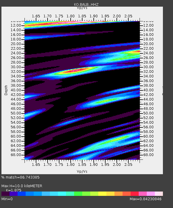
BALB Balikesir-Turkiye - Earthquake Result Viewer
| Earthquake location: |
Off W Coast Of Northern Sumatra |
| Earthquake latitude/longitude: |
0.1/96.6 |
| Earthquake time(UTC): |
2021/05/14 (134) 06:33:07 GMT |
| Earthquake Depth: |
11 km |
| Earthquake Magnitude: |
6.7 mww |
| Earthquake Catalog/Contributor: |
NEIC PDE/us |
|
| Network: |
KO Kandilli Observatory Digital Broadband Seismic Network |
| Station: |
BALB Balikesir-Turkiye |
| Lat/Lon: |
39.64 N/27.88 E |
| Elevation: |
120 m |
|
| Distance: |
73.7 deg |
| Az: |
311.41 deg |
| Baz: |
103.764 deg |
| Ray Param: |
0.052849017 |
| Estimated Moho Depth: |
10.0 km |
| Estimated Crust Vp/Vs: |
1.88 |
| Assumed Crust Vp: |
6.155 km/s |
| Estimated Crust Vs: |
3.283 km/s |
| Estimated Crust Poisson's Ratio: |
0.30 |
|
| Radial Match: |
86.743385 % |
| Radial Bump: |
273 |
| Transverse Match: |
86.50625 % |
| Transverse Bump: |
400 |
| SOD ConfigId: |
24890451 |
| Insert Time: |
2021-06-02 17:01:00.969 +0000 |
| GWidth: |
2.5 |
| Max Bumps: |
400 |
| Tol: |
0.001 |
|

Signal To Noise
| Channel | StoN | STA | LTA |
| KO:BALB: :HHZ:20210514T06:44:10.129977Z | 13.455731 | 1.0347037E-6 | 7.6896875E-8 |
| KO:BALB: :HHN:20210514T06:44:10.129977Z | 1.2920405 | 1.5947538E-7 | 1.2342909E-7 |
| KO:BALB: :HHE:20210514T06:44:10.129977Z | 3.0945446 | 2.3919475E-7 | 7.7295624E-8 |
| Arrivals |
| Ps | 1.5 SECOND |
| PpPs | 4.5 SECOND |
| PsPs/PpSs | 6.0 SECOND |


