You are here: Home > Network List > NW - Northwestern University Seismic Network Stations List
> Station HQIL Hanson (Federal McCook) Quary, Illinois, U.S.A. > Earthquake Result Viewer
HQIL Hanson (Federal McCook) Quary, Illinois, U.S.A. - Earthquake Result Viewer
| Earthquake location: |
Central Mid-Atlantic Ridge |
| Earthquake latitude/longitude: |
-1.1/-23.5 |
| Earthquake time(UTC): |
2017/11/30 (334) 06:32:52 GMT |
| Earthquake Depth: |
10 km |
| Earthquake Magnitude: |
6.5 Mi |
| Earthquake Catalog/Contributor: |
NEIC PDE/at |
|
| Network: |
NW Northwestern University Seismic Network |
| Station: |
HQIL Hanson (Federal McCook) Quary, Illinois, U.S.A. |
| Lat/Lon: |
41.80 N/87.85 W |
| Elevation: |
193 m |
|
| Distance: |
71.9 deg |
| Az: |
314.832 deg |
| Baz: |
108.502 deg |
| Ray Param: |
0.054028332 |
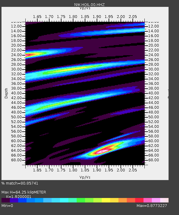
| Estimated Moho Depth: |
64.25 km |
| Estimated Crust Vp/Vs: |
1.92 |
| Assumed Crust Vp: |
6.498 km/s |
| Estimated Crust Vs: |
3.384 km/s |
| Estimated Crust Poisson's Ratio: |
0.31 |
|
| Radial Match: |
80.85741 % |
| Radial Bump: |
313 |
| Transverse Match: |
56.67408 % |
| Transverse Bump: |
400 |
| SOD ConfigId: |
2429771 |
| Insert Time: |
2017-12-14 06:39:55.027 +0000 |
| GWidth: |
2.5 |
| Max Bumps: |
400 |
| Tol: |
0.001 |
|

Signal To Noise
| Channel | StoN | STA | LTA |
| NW:HQIL:00:HHZ:20171130T06:43:43.85498Z | 4.5443115 | 1.978982E-6 | 4.3548556E-7 |
| NW:HQIL:00:HH1:20171130T06:43:43.85498Z | 1.701213 | 5.6405014E-7 | 3.3155763E-7 |
| NW:HQIL:00:HH2:20171130T06:43:43.85498Z | 4.114056 | 1.0098465E-6 | 2.454625E-7 |
| Arrivals |
| Ps | 9.4 SECOND |
| PpPs | 28 SECOND |
| PsPs/PpSs | 37 SECOND |


