You are here: Home > Network List > AK - Alaska Regional Network Stations List
> Station B18K Kokolik River, AK, USA > Earthquake Result Viewer
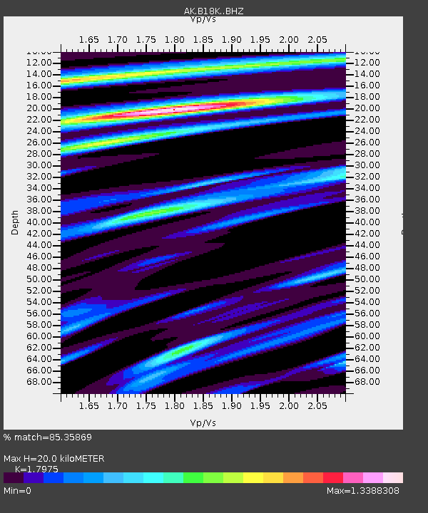
B18K Kokolik River, AK, USA - Earthquake Result Viewer
| Earthquake location: |
Hokkaido, Japan Region |
| Earthquake latitude/longitude: |
42.0/144.5 |
| Earthquake time(UTC): |
2021/05/16 (136) 03:23:54 GMT |
| Earthquake Depth: |
17 km |
| Earthquake Magnitude: |
5.7 mww |
| Earthquake Catalog/Contributor: |
NEIC PDE/us |
|
| Network: |
AK Alaska Regional Network |
| Station: |
B18K Kokolik River, AK, USA |
| Lat/Lon: |
69.36 N/161.80 W |
| Elevation: |
222 m |
|
| Distance: |
38.7 deg |
| Az: |
27.177 deg |
| Baz: |
253.698 deg |
| Ray Param: |
0.07540134 |
| Estimated Moho Depth: |
20.0 km |
| Estimated Crust Vp/Vs: |
1.80 |
| Assumed Crust Vp: |
5.906 km/s |
| Estimated Crust Vs: |
3.286 km/s |
| Estimated Crust Poisson's Ratio: |
0.28 |
|
| Radial Match: |
85.35869 % |
| Radial Bump: |
400 |
| Transverse Match: |
75.655655 % |
| Transverse Bump: |
400 |
| SOD ConfigId: |
24890451 |
| Insert Time: |
2021-06-02 17:18:31.956 +0000 |
| GWidth: |
2.5 |
| Max Bumps: |
400 |
| Tol: |
0.001 |
|

Signal To Noise
| Channel | StoN | STA | LTA |
| AK:B18K: :BHZ:20210516T03:30:46.860004Z | 5.3939853 | 7.351786E-7 | 1.36296E-7 |
| AK:B18K: :BHN:20210516T03:30:46.860004Z | 1.9158784 | 1.1114254E-7 | 5.801127E-8 |
| AK:B18K: :BHE:20210516T03:30:46.860004Z | 4.4861307 | 2.443228E-7 | 5.446181E-8 |
| Arrivals |
| Ps | 2.9 SECOND |
| PpPs | 8.9 SECOND |
| PsPs/PpSs | 12 SECOND |


