You are here: Home > Network List > TA - USArray Transportable Network (new EarthScope stations) Stations List
> Station TUL3 Leonard, OK, USA > Earthquake Result Viewer
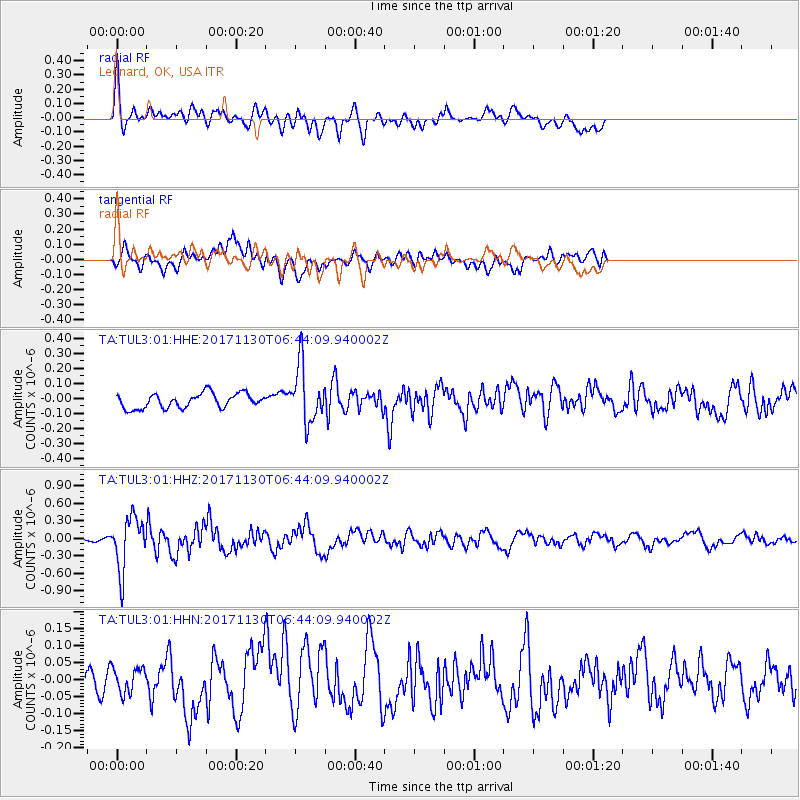
TUL3 Leonard, OK, USA - Earthquake Result Viewer
*The percent match for this event was below the threshold and hence no stack was calculated.
| Earthquake location: |
Central Mid-Atlantic Ridge |
| Earthquake latitude/longitude: |
-1.1/-23.5 |
| Earthquake time(UTC): |
2017/11/30 (334) 06:32:52 GMT |
| Earthquake Depth: |
10 km |
| Earthquake Magnitude: |
6.5 Mi |
| Earthquake Catalog/Contributor: |
NEIC PDE/at |
|
| Network: |
TA USArray Transportable Network (new EarthScope stations) |
| Station: |
TUL3 Leonard, OK, USA |
| Lat/Lon: |
35.91 N/95.79 W |
| Elevation: |
265 m |
|
| Distance: |
76.4 deg |
| Az: |
307.273 deg |
| Baz: |
101.459 deg |
| Ray Param: |
$rayparam |
*The percent match for this event was below the threshold and hence was not used in the summary stack. |
|
| Radial Match: |
75.48709 % |
| Radial Bump: |
400 |
| Transverse Match: |
59.848736 % |
| Transverse Bump: |
400 |
| SOD ConfigId: |
2429771 |
| Insert Time: |
2017-12-14 06:40:21.676 +0000 |
| GWidth: |
2.5 |
| Max Bumps: |
400 |
| Tol: |
0.001 |
|
Signal To Noise
| Channel | StoN | STA | LTA |
| TA:TUL3:01:HHZ:20171130T06:44:09.940002Z | 8.153289 | 4.4991145E-7 | 5.5181594E-8 |
| TA:TUL3:01:HHN:20171130T06:44:09.940002Z | 1.0231415 | 3.8429597E-8 | 3.7560394E-8 |
| TA:TUL3:01:HHE:20171130T06:44:09.940002Z | 3.8284643 | 1.872227E-7 | 4.890282E-8 |
| Arrivals |
| Ps | |
| PpPs | |
| PsPs/PpSs | |


