You are here: Home > Network List > AK - Alaska Regional Network Stations List
> Station H20K Anotleneega Mountain, AK, USA > Earthquake Result Viewer
H20K Anotleneega Mountain, AK, USA - Earthquake Result Viewer
| Earthquake location: |
Hokkaido, Japan Region |
| Earthquake latitude/longitude: |
42.0/144.5 |
| Earthquake time(UTC): |
2021/05/16 (136) 03:23:54 GMT |
| Earthquake Depth: |
17 km |
| Earthquake Magnitude: |
5.7 mww |
| Earthquake Catalog/Contributor: |
NEIC PDE/us |
|
| Network: |
AK Alaska Regional Network |
| Station: |
H20K Anotleneega Mountain, AK, USA |
| Lat/Lon: |
65.49 N/154.88 W |
| Elevation: |
514 m |
|
| Distance: |
40.7 deg |
| Az: |
33.92 deg |
| Baz: |
265.278 deg |
| Ray Param: |
0.07425681 |
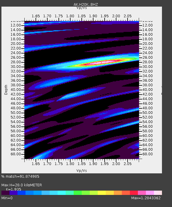
| Estimated Moho Depth: |
28.0 km |
| Estimated Crust Vp/Vs: |
1.93 |
| Assumed Crust Vp: |
6.566 km/s |
| Estimated Crust Vs: |
3.393 km/s |
| Estimated Crust Poisson's Ratio: |
0.32 |
|
| Radial Match: |
91.874985 % |
| Radial Bump: |
326 |
| Transverse Match: |
66.3886 % |
| Transverse Bump: |
400 |
| SOD ConfigId: |
24890451 |
| Insert Time: |
2021-06-02 17:19:07.617 +0000 |
| GWidth: |
2.5 |
| Max Bumps: |
400 |
| Tol: |
0.001 |
|

Signal To Noise
| Channel | StoN | STA | LTA |
| AK:H20K: :BHZ:20210516T03:31:02.819995Z | 6.512691 | 4.8381355E-7 | 7.4287804E-8 |
| AK:H20K: :BHN:20210516T03:31:02.819995Z | 1.2275974 | 5.394949E-8 | 4.3947217E-8 |
| AK:H20K: :BHE:20210516T03:31:02.819995Z | 5.921589 | 3.053563E-7 | 5.1566616E-8 |
| Arrivals |
| Ps | 4.3 SECOND |
| PpPs | 12 SECOND |
| PsPs/PpSs | 16 SECOND |


