You are here: Home > Network List > GO - National Seismic Network of Georgia Stations List
> Station TBLG Delisi, Georgia > Earthquake Result Viewer
TBLG Delisi, Georgia - Earthquake Result Viewer

| Earthquake location: |
Hokkaido, Japan Region |
| Earthquake latitude/longitude: |
42.0/144.5 |
| Earthquake time(UTC): |
2021/05/16 (136) 03:23:54 GMT |
| Earthquake Depth: |
17 km |
| Earthquake Magnitude: |
5.7 mww |
| Earthquake Catalog/Contributor: |
NEIC PDE/us |
|
| Network: |
GO National Seismic Network of Georgia |
| Station: |
TBLG Delisi, Georgia |
| Lat/Lon: |
41.73 N/44.74 E |
| Elevation: |
510 m |
|
| Distance: |
69.6 deg |
| Az: |
308.1 deg |
| Baz: |
51.555 deg |
| Ray Param: |
0.05550811 |
| Estimated Moho Depth: |
63.0 km |
| Estimated Crust Vp/Vs: |
1.93 |
| Assumed Crust Vp: |
6.291 km/s |
| Estimated Crust Vs: |
3.255 km/s |
| Estimated Crust Poisson's Ratio: |
0.32 |
|
| Radial Match: |
89.15623 % |
| Radial Bump: |
400 |
| Transverse Match: |
79.02591 % |
| Transverse Bump: |
400 |
| SOD ConfigId: |
24890451 |
| Insert Time: |
2021-06-02 17:27:41.997 +0000 |
| GWidth: |
2.5 |
| Max Bumps: |
400 |
| Tol: |
0.001 |
|
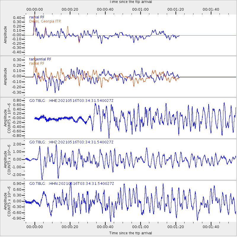
Signal To Noise
| Channel | StoN | STA | LTA |
| GO:TBLG: :HHZ:20210516T03:34:31.540027Z | 13.023733 | 1.1146719E-6 | 8.558774E-8 |
| GO:TBLG: :HHN:20210516T03:34:31.540027Z | 1.5249856 | 1.4857022E-7 | 9.742402E-8 |
| GO:TBLG: :HHE:20210516T03:34:31.540027Z | 4.8142443 | 3.0946035E-7 | 6.428015E-8 |
| Arrivals |
| Ps | 9.7 SECOND |
| PpPs | 28 SECOND |
| PsPs/PpSs | 38 SECOND |


