You are here: Home > Network List > MS - IRIS/Singapore, Singapore National Network (GSN) Stations List
> Station UBIN Ubin > Earthquake Result Viewer
UBIN Ubin - Earthquake Result Viewer
| Earthquake location: |
Hokkaido, Japan Region |
| Earthquake latitude/longitude: |
42.0/144.5 |
| Earthquake time(UTC): |
2021/05/16 (136) 03:23:54 GMT |
| Earthquake Depth: |
17 km |
| Earthquake Magnitude: |
5.7 mww |
| Earthquake Catalog/Contributor: |
NEIC PDE/us |
|
| Network: |
MS IRIS/Singapore, Singapore National Network (GSN) |
| Station: |
UBIN Ubin |
| Lat/Lon: |
1.42 N/103.95 E |
| Elevation: |
26 m |
|
| Distance: |
54.4 deg |
| Az: |
233.044 deg |
| Baz: |
36.546 deg |
| Ray Param: |
0.06548441 |
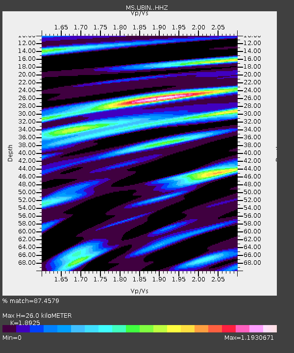
| Estimated Moho Depth: |
26.0 km |
| Estimated Crust Vp/Vs: |
1.89 |
| Assumed Crust Vp: |
6.24 km/s |
| Estimated Crust Vs: |
3.297 km/s |
| Estimated Crust Poisson's Ratio: |
0.31 |
|
| Radial Match: |
87.4579 % |
| Radial Bump: |
400 |
| Transverse Match: |
83.11462 % |
| Transverse Bump: |
400 |
| SOD ConfigId: |
24890451 |
| Insert Time: |
2021-06-02 17:30:53.381 +0000 |
| GWidth: |
2.5 |
| Max Bumps: |
400 |
| Tol: |
0.001 |
|

Signal To Noise
| Channel | StoN | STA | LTA |
| MS:UBIN: :HHZ:20210516T03:32:49.238025Z | 10.67552 | 9.2090227E-7 | 8.626299E-8 |
| MS:UBIN: :HHN:20210516T03:32:49.238025Z | 3.2986183 | 2.3578373E-7 | 7.147955E-8 |
| MS:UBIN: :HHE:20210516T03:32:49.238025Z | 6.287517 | 4.2420896E-7 | 6.7468434E-8 |
| Arrivals |
| Ps | 3.9 SECOND |
| PpPs | 12 SECOND |
| PsPs/PpSs | 15 SECOND |


