You are here: Home > Network List > TA - USArray Transportable Network (new EarthScope stations) Stations List
> Station A36M Sachs Harbour, NT, CAN > Earthquake Result Viewer
A36M Sachs Harbour, NT, CAN - Earthquake Result Viewer

| Earthquake location: |
Hokkaido, Japan Region |
| Earthquake latitude/longitude: |
42.0/144.5 |
| Earthquake time(UTC): |
2021/05/16 (136) 03:23:54 GMT |
| Earthquake Depth: |
17 km |
| Earthquake Magnitude: |
5.7 mww |
| Earthquake Catalog/Contributor: |
NEIC PDE/us |
|
| Network: |
TA USArray Transportable Network (new EarthScope stations) |
| Station: |
A36M Sachs Harbour, NT, CAN |
| Lat/Lon: |
71.99 N/125.25 W |
| Elevation: |
32 m |
|
| Distance: |
50.7 deg |
| Az: |
23.692 deg |
| Baz: |
285.814 deg |
| Ray Param: |
0.06783789 |
| Estimated Moho Depth: |
22.75 km |
| Estimated Crust Vp/Vs: |
1.80 |
| Assumed Crust Vp: |
6.24 km/s |
| Estimated Crust Vs: |
3.476 km/s |
| Estimated Crust Poisson's Ratio: |
0.27 |
|
| Radial Match: |
93.999954 % |
| Radial Bump: |
400 |
| Transverse Match: |
85.01001 % |
| Transverse Bump: |
400 |
| SOD ConfigId: |
24890451 |
| Insert Time: |
2021-06-02 17:39:21.625 +0000 |
| GWidth: |
2.5 |
| Max Bumps: |
400 |
| Tol: |
0.001 |
|
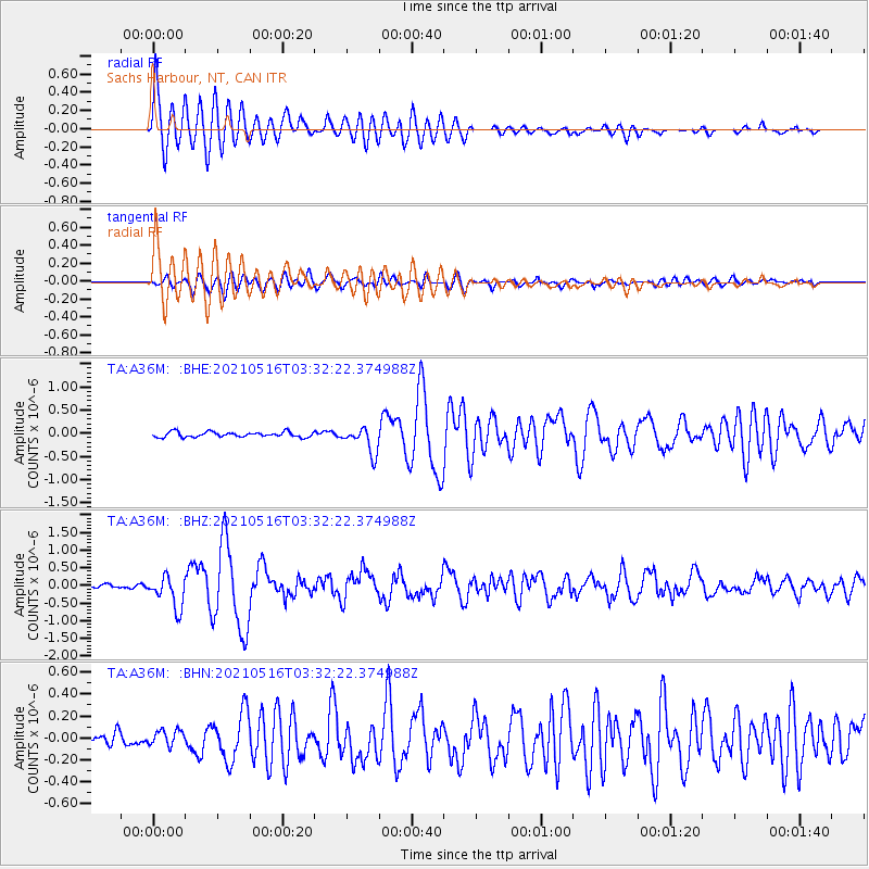
Signal To Noise
| Channel | StoN | STA | LTA |
| TA:A36M: :BHZ:20210516T03:32:22.374988Z | 7.2378654 | 4.4404263E-7 | 6.1349944E-8 |
| TA:A36M: :BHN:20210516T03:32:22.374988Z | 1.4342796 | 6.987653E-8 | 4.8718903E-8 |
| TA:A36M: :BHE:20210516T03:32:22.374988Z | 5.073033 | 2.830086E-7 | 5.5786863E-8 |
| Arrivals |
| Ps | 3.1 SECOND |
| PpPs | 9.7 SECOND |
| PsPs/PpSs | 13 SECOND |


