You are here: Home > Network List > TA - USArray Transportable Network (new EarthScope stations) Stations List
> Station C36M Paulatuk, NT, CAN > Earthquake Result Viewer
C36M Paulatuk, NT, CAN - Earthquake Result Viewer
| Earthquake location: |
Hokkaido, Japan Region |
| Earthquake latitude/longitude: |
42.0/144.5 |
| Earthquake time(UTC): |
2021/05/16 (136) 03:23:54 GMT |
| Earthquake Depth: |
17 km |
| Earthquake Magnitude: |
5.7 mww |
| Earthquake Catalog/Contributor: |
NEIC PDE/us |
|
| Network: |
TA USArray Transportable Network (new EarthScope stations) |
| Station: |
C36M Paulatuk, NT, CAN |
| Lat/Lon: |
69.35 N/124.07 W |
| Elevation: |
10 m |
|
| Distance: |
51.9 deg |
| Az: |
26.787 deg |
| Baz: |
288.859 deg |
| Ray Param: |
0.06709471 |
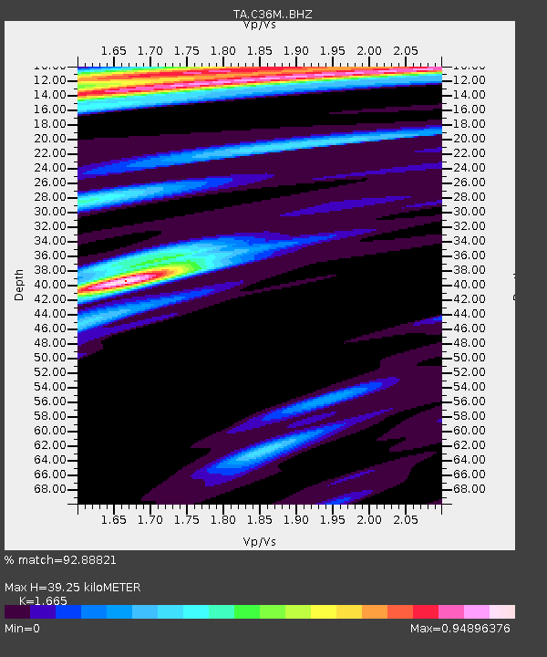
| Estimated Moho Depth: |
39.25 km |
| Estimated Crust Vp/Vs: |
1.66 |
| Assumed Crust Vp: |
6.459 km/s |
| Estimated Crust Vs: |
3.88 km/s |
| Estimated Crust Poisson's Ratio: |
0.22 |
|
| Radial Match: |
92.88821 % |
| Radial Bump: |
364 |
| Transverse Match: |
79.484024 % |
| Transverse Bump: |
400 |
| SOD ConfigId: |
24890451 |
| Insert Time: |
2021-06-02 17:39:22.271 +0000 |
| GWidth: |
2.5 |
| Max Bumps: |
400 |
| Tol: |
0.001 |
|

Signal To Noise
| Channel | StoN | STA | LTA |
| TA:C36M: :BHZ:20210516T03:32:31.075Z | 8.536425 | 7.0143557E-7 | 8.216971E-8 |
| TA:C36M: :BHN:20210516T03:32:31.075Z | 1.7851553 | 1.2284406E-7 | 6.881421E-8 |
| TA:C36M: :BHE:20210516T03:32:31.075Z | 3.0514264 | 1.977344E-7 | 6.480064E-8 |
| Arrivals |
| Ps | 4.3 SECOND |
| PpPs | 15 SECOND |
| PsPs/PpSs | 20 SECOND |


