You are here: Home > Network List > TA - USArray Transportable Network (new EarthScope stations) Stations List
> Station F28M Old Crow, YT, CAN > Earthquake Result Viewer
F28M Old Crow, YT, CAN - Earthquake Result Viewer
| Earthquake location: |
Hokkaido, Japan Region |
| Earthquake latitude/longitude: |
42.0/144.5 |
| Earthquake time(UTC): |
2021/05/16 (136) 03:23:54 GMT |
| Earthquake Depth: |
17 km |
| Earthquake Magnitude: |
5.7 mww |
| Earthquake Catalog/Contributor: |
NEIC PDE/us |
|
| Network: |
TA USArray Transportable Network (new EarthScope stations) |
| Station: |
F28M Old Crow, YT, CAN |
| Lat/Lon: |
67.61 N/139.87 W |
| Elevation: |
564 m |
|
| Distance: |
46.6 deg |
| Az: |
30.707 deg |
| Baz: |
276.72 deg |
| Ray Param: |
0.070522025 |
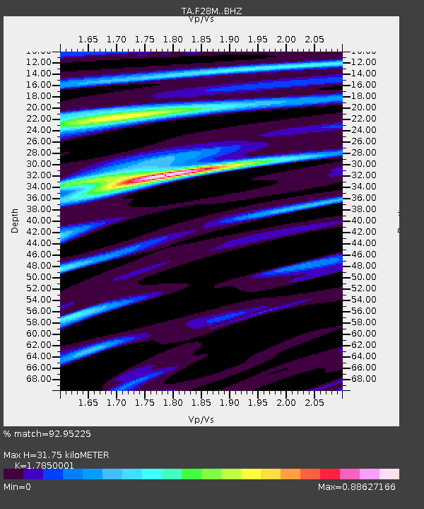
| Estimated Moho Depth: |
31.75 km |
| Estimated Crust Vp/Vs: |
1.79 |
| Assumed Crust Vp: |
6.577 km/s |
| Estimated Crust Vs: |
3.684 km/s |
| Estimated Crust Poisson's Ratio: |
0.27 |
|
| Radial Match: |
92.95225 % |
| Radial Bump: |
320 |
| Transverse Match: |
85.66637 % |
| Transverse Bump: |
400 |
| SOD ConfigId: |
24890451 |
| Insert Time: |
2021-06-02 17:39:28.760 +0000 |
| GWidth: |
2.5 |
| Max Bumps: |
400 |
| Tol: |
0.001 |
|
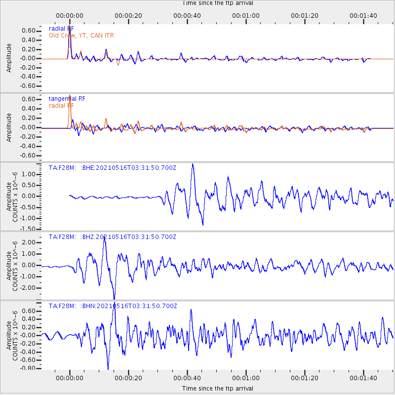
Signal To Noise
| Channel | StoN | STA | LTA |
| TA:F28M: :BHZ:20210516T03:31:50.700Z | 8.840516 | 4.85579E-7 | 5.4926545E-8 |
| TA:F28M: :BHN:20210516T03:31:50.700Z | 1.3439668 | 7.215242E-8 | 5.368616E-8 |
| TA:F28M: :BHE:20210516T03:31:50.700Z | 7.0317044 | 2.3290492E-7 | 3.3122117E-8 |
| Arrivals |
| Ps | 4.0 SECOND |
| PpPs | 13 SECOND |
| PsPs/PpSs | 17 SECOND |


