You are here: Home > Network List > TX - Texas Seismological Network Stations List
> Station MB07 West Midland > Earthquake Result Viewer
MB07 West Midland - Earthquake Result Viewer
| Earthquake location: |
Hokkaido, Japan Region |
| Earthquake latitude/longitude: |
42.0/144.5 |
| Earthquake time(UTC): |
2021/05/16 (136) 03:23:54 GMT |
| Earthquake Depth: |
17 km |
| Earthquake Magnitude: |
5.7 mww |
| Earthquake Catalog/Contributor: |
NEIC PDE/us |
|
| Network: |
TX Texas Seismological Network |
| Station: |
MB07 West Midland |
| Lat/Lon: |
32.00 N/102.25 W |
| Elevation: |
880 m |
|
| Distance: |
84.2 deg |
| Az: |
51.681 deg |
| Baz: |
316.536 deg |
| Ray Param: |
0.045666903 |
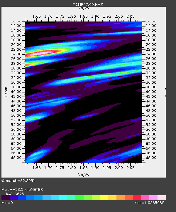
| Estimated Moho Depth: |
23.5 km |
| Estimated Crust Vp/Vs: |
1.66 |
| Assumed Crust Vp: |
6.129 km/s |
| Estimated Crust Vs: |
3.687 km/s |
| Estimated Crust Poisson's Ratio: |
0.22 |
|
| Radial Match: |
82.3951 % |
| Radial Bump: |
392 |
| Transverse Match: |
56.85811 % |
| Transverse Bump: |
400 |
| SOD ConfigId: |
24890451 |
| Insert Time: |
2021-06-02 17:40:23.838 +0000 |
| GWidth: |
2.5 |
| Max Bumps: |
400 |
| Tol: |
0.001 |
|

Signal To Noise
| Channel | StoN | STA | LTA |
| TX:MB07:00:HHZ:20210516T03:35:53.129993Z | 4.196913 | 2.1913627E-7 | 5.221368E-8 |
| TX:MB07:00:HH1:20210516T03:35:53.129993Z | 0.96640563 | 7.240991E-8 | 7.492704E-8 |
| TX:MB07:00:HH2:20210516T03:35:53.129993Z | 0.538523 | 4.191013E-8 | 7.782421E-8 |
| Arrivals |
| Ps | 2.6 SECOND |
| PpPs | 10.0 SECOND |
| PsPs/PpSs | 13 SECOND |


