You are here: Home > Network List > US - United States National Seismic Network Stations List
> Station AMTX Amarillo, Texas, USA > Earthquake Result Viewer
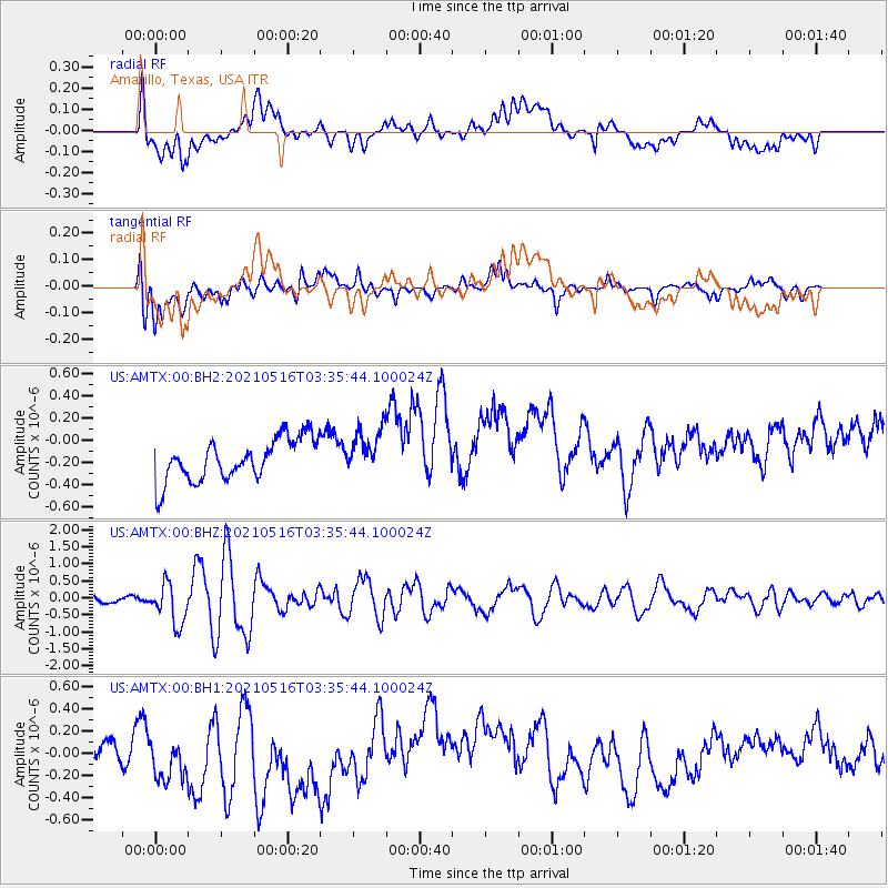
AMTX Amarillo, Texas, USA - Earthquake Result Viewer
*The percent match for this event was below the threshold and hence no stack was calculated.
| Earthquake location: |
Hokkaido, Japan Region |
| Earthquake latitude/longitude: |
42.0/144.5 |
| Earthquake time(UTC): |
2021/05/16 (136) 03:23:54 GMT |
| Earthquake Depth: |
17 km |
| Earthquake Magnitude: |
5.7 mww |
| Earthquake Catalog/Contributor: |
NEIC PDE/us |
|
| Network: |
US United States National Seismic Network |
| Station: |
AMTX Amarillo, Texas, USA |
| Lat/Lon: |
34.53 N/101.41 W |
| Elevation: |
1010 m |
|
| Distance: |
82.8 deg |
| Az: |
49.42 deg |
| Baz: |
316.74 deg |
| Ray Param: |
$rayparam |
*The percent match for this event was below the threshold and hence was not used in the summary stack. |
|
| Radial Match: |
33.794437 % |
| Radial Bump: |
400 |
| Transverse Match: |
52.83738 % |
| Transverse Bump: |
400 |
| SOD ConfigId: |
24890451 |
| Insert Time: |
2021-06-02 17:41:33.196 +0000 |
| GWidth: |
2.5 |
| Max Bumps: |
400 |
| Tol: |
0.001 |
|
Signal To Noise
| Channel | StoN | STA | LTA |
| US:AMTX:00:BHZ:20210516T03:35:44.100024Z | 3.2834876 | 5.9711886E-7 | 1.8185509E-7 |
| US:AMTX:00:BH1:20210516T03:35:44.100024Z | 1.4706405 | 2.8719487E-7 | 1.9528555E-7 |
| US:AMTX:00:BH2:20210516T03:35:44.100024Z | 1.7280792 | 2.8919575E-7 | 1.6735098E-7 |
| Arrivals |
| Ps | |
| PpPs | |
| PsPs/PpSs | |


