You are here: Home > Network List > US - United States National Seismic Network Stations List
> Station EGMT Eagleton, Montana, USA > Earthquake Result Viewer
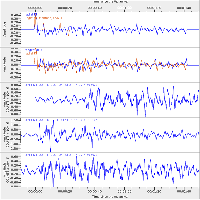
EGMT Eagleton, Montana, USA - Earthquake Result Viewer
*The percent match for this event was below the threshold and hence no stack was calculated.
| Earthquake location: |
Hokkaido, Japan Region |
| Earthquake latitude/longitude: |
42.0/144.5 |
| Earthquake time(UTC): |
2021/05/16 (136) 03:23:54 GMT |
| Earthquake Depth: |
17 km |
| Earthquake Magnitude: |
5.7 mww |
| Earthquake Catalog/Contributor: |
NEIC PDE/us |
|
| Network: |
US United States National Seismic Network |
| Station: |
EGMT Eagleton, Montana, USA |
| Lat/Lon: |
48.02 N/109.75 W |
| Elevation: |
1055 m |
|
| Distance: |
69.0 deg |
| Az: |
43.792 deg |
| Baz: |
309.829 deg |
| Ray Param: |
$rayparam |
*The percent match for this event was below the threshold and hence was not used in the summary stack. |
|
| Radial Match: |
78.751656 % |
| Radial Bump: |
400 |
| Transverse Match: |
69.233215 % |
| Transverse Bump: |
400 |
| SOD ConfigId: |
24890451 |
| Insert Time: |
2021-06-02 17:41:47.078 +0000 |
| GWidth: |
2.5 |
| Max Bumps: |
400 |
| Tol: |
0.001 |
|
Signal To Noise
| Channel | StoN | STA | LTA |
| US:EGMT:00:BHZ:20210516T03:34:27.598987Z | 4.9252286 | 4.3753616E-7 | 8.8835705E-8 |
| US:EGMT:00:BH1:20210516T03:34:27.598987Z | 1.2800847 | 1.3609676E-7 | 1.0631856E-7 |
| US:EGMT:00:BH2:20210516T03:34:27.598987Z | 1.1815103 | 1.2405943E-7 | 1.05000716E-7 |
| Arrivals |
| Ps | |
| PpPs | |
| PsPs/PpSs | |


