You are here: Home > Network List > US - United States National Seismic Network Stations List
> Station HAWA Hanford, Washington, USA > Earthquake Result Viewer
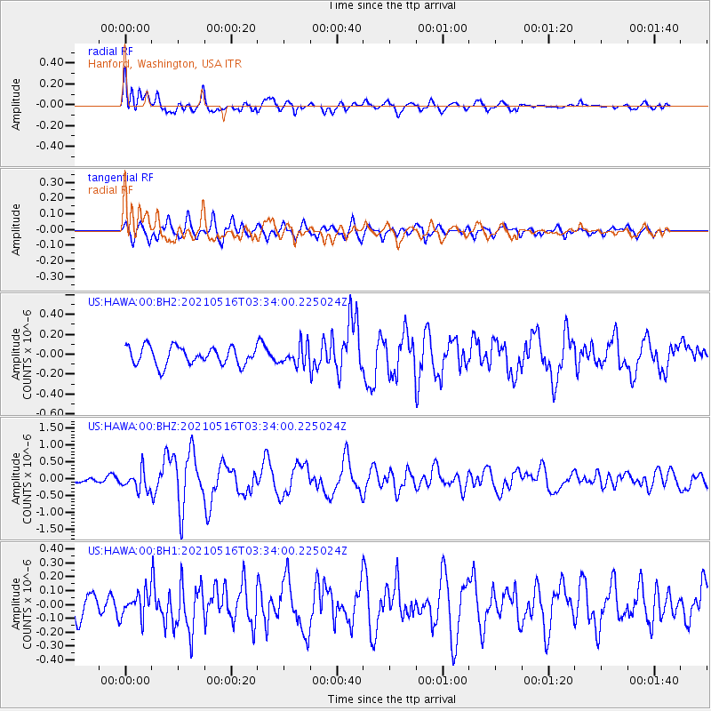
HAWA Hanford, Washington, USA - Earthquake Result Viewer
*The percent match for this event was below the threshold and hence no stack was calculated.
| Earthquake location: |
Hokkaido, Japan Region |
| Earthquake latitude/longitude: |
42.0/144.5 |
| Earthquake time(UTC): |
2021/05/16 (136) 03:23:54 GMT |
| Earthquake Depth: |
17 km |
| Earthquake Magnitude: |
5.7 mww |
| Earthquake Catalog/Contributor: |
NEIC PDE/us |
|
| Network: |
US United States National Seismic Network |
| Station: |
HAWA Hanford, Washington, USA |
| Lat/Lon: |
46.39 N/119.53 W |
| Elevation: |
364 m |
|
| Distance: |
64.7 deg |
| Az: |
49.598 deg |
| Baz: |
304.954 deg |
| Ray Param: |
$rayparam |
*The percent match for this event was below the threshold and hence was not used in the summary stack. |
|
| Radial Match: |
77.66346 % |
| Radial Bump: |
400 |
| Transverse Match: |
68.85312 % |
| Transverse Bump: |
400 |
| SOD ConfigId: |
24890451 |
| Insert Time: |
2021-06-02 17:41:53.310 +0000 |
| GWidth: |
2.5 |
| Max Bumps: |
400 |
| Tol: |
0.001 |
|
Signal To Noise
| Channel | StoN | STA | LTA |
| US:HAWA:00:BHZ:20210516T03:34:00.225024Z | 4.0066285 | 2.9498162E-7 | 7.3623404E-8 |
| US:HAWA:00:BH1:20210516T03:34:00.225024Z | 0.9898439 | 8.775703E-8 | 8.8657444E-8 |
| US:HAWA:00:BH2:20210516T03:34:00.225024Z | 1.1150929 | 1.001752E-7 | 8.9835744E-8 |
| Arrivals |
| Ps | |
| PpPs | |
| PsPs/PpSs | |


