You are here: Home > Network List > XH02 - Western Anatolia Linear Array and Regional Network Stations List
> Station BOZ Bozdag Military Base > Earthquake Result Viewer
BOZ Bozdag Military Base - Earthquake Result Viewer
| Earthquake location: |
Kuril Islands |
| Earthquake latitude/longitude: |
43.7/147.8 |
| Earthquake time(UTC): |
2003/04/29 (119) 13:53:17 GMT |
| Earthquake Depth: |
62 km |
| Earthquake Magnitude: |
6.0 MB, 6.0 MW, 5.9 MW |
| Earthquake Catalog/Contributor: |
WHDF/NEIC |
|
| Network: |
XH Western Anatolia Linear Array and Regional Network |
| Station: |
BOZ Bozdag Military Base |
| Lat/Lon: |
38.30 N/28.05 E |
| Elevation: |
1216 m |
|
| Distance: |
81.8 deg |
| Az: |
316.368 deg |
| Baz: |
39.495 deg |
| Ray Param: |
0.04717667 |
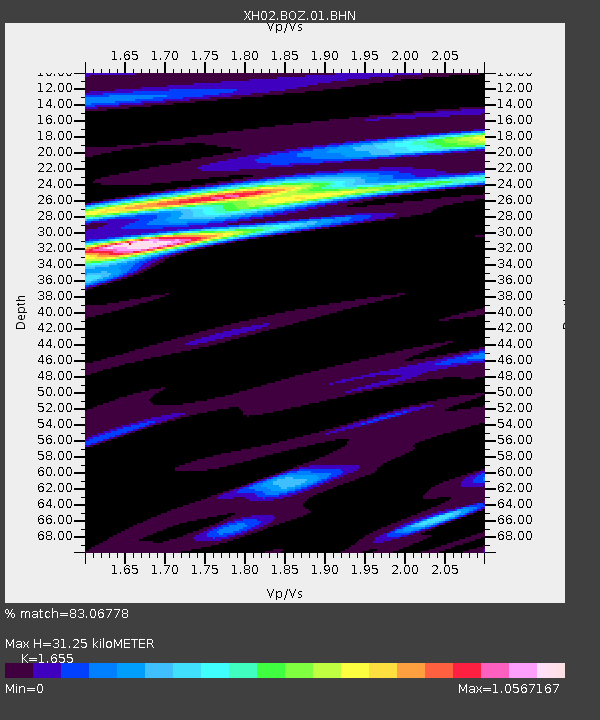
| Estimated Moho Depth: |
31.25 km |
| Estimated Crust Vp/Vs: |
1.65 |
| Assumed Crust Vp: |
6.291 km/s |
| Estimated Crust Vs: |
3.801 km/s |
| Estimated Crust Poisson's Ratio: |
0.21 |
|
| Radial Match: |
83.06778 % |
| Radial Bump: |
400 |
| Transverse Match: |
83.053986 % |
| Transverse Bump: |
400 |
| SOD ConfigId: |
16820 |
| Insert Time: |
2010-03-09 08:24:55.758 +0000 |
| GWidth: |
2.5 |
| Max Bumps: |
400 |
| Tol: |
0.001 |
|

Signal To Noise
| Channel | StoN | STA | LTA |
| XH:BOZ:01:BHN:20030429T14:04:58.653027Z | 9.030462 | 5.535767E-7 | 6.130104E-8 |
| XH:BOZ:01:BHE:20030429T14:04:58.653027Z | 3.1767337 | 1.9026196E-7 | 5.989232E-8 |
| XH:BOZ:01:BHZ:20030429T14:04:58.653027Z | 23.154018 | 1.2673114E-6 | 5.4733974E-8 |
| Arrivals |
| Ps | 3.3 SECOND |
| PpPs | 13 SECOND |
| PsPs/PpSs | 16 SECOND |


