You are here: Home > Network List > KZ - Kazakhstan Network Stations List
> Station ABKAR Akbulak array,AB31, Kazakhstan > Earthquake Result Viewer
ABKAR Akbulak array,AB31, Kazakhstan - Earthquake Result Viewer
| Earthquake location: |
Nicobar Islands, India Region |
| Earthquake latitude/longitude: |
7.9/92.2 |
| Earthquake time(UTC): |
2005/07/24 (205) 15:42:06 GMT |
| Earthquake Depth: |
16 km |
| Earthquake Magnitude: |
6.6 MB, 7.5 MS, 7.3 MW, 7.2 MW |
| Earthquake Catalog/Contributor: |
WHDF/NEIC |
|
| Network: |
KZ Kazakhstan Network |
| Station: |
ABKAR Akbulak array,AB31, Kazakhstan |
| Lat/Lon: |
49.26 N/59.94 E |
| Elevation: |
362 m |
|
| Distance: |
49.3 deg |
| Az: |
332.533 deg |
| Baz: |
135.785 deg |
| Ray Param: |
0.06878435 |
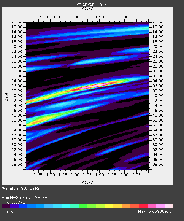
| Estimated Moho Depth: |
35.75 km |
| Estimated Crust Vp/Vs: |
1.88 |
| Assumed Crust Vp: |
6.35 km/s |
| Estimated Crust Vs: |
3.382 km/s |
| Estimated Crust Poisson's Ratio: |
0.30 |
|
| Radial Match: |
98.75992 % |
| Radial Bump: |
293 |
| Transverse Match: |
94.47045 % |
| Transverse Bump: |
400 |
| SOD ConfigId: |
2564 |
| Insert Time: |
2010-03-09 08:25:58.347 +0000 |
| GWidth: |
2.5 |
| Max Bumps: |
400 |
| Tol: |
0.001 |
|

Signal To Noise
| Channel | StoN | STA | LTA |
| KZ:ABKAR: :BHN:20050724T15:50:23.225015Z | 61.29644 | 1.8682658E-6 | 3.047919E-8 |
| KZ:ABKAR: :BHE:20050724T15:50:23.225015Z | 63.813877 | 2.6627392E-6 | 4.1726647E-8 |
| KZ:ABKAR: :BHZ:20050724T15:50:23.225015Z | 70.18858 | 5.04154E-6 | 7.1828495E-8 |
| Arrivals |
| Ps | 5.2 SECOND |
| PpPs | 15 SECOND |
| PsPs/PpSs | 21 SECOND |


