You are here: Home > Network List > WI - West Indies IPGP Network Stations List
> Station MPOM Morne Pois, Sainte-Anne, Martinique > Earthquake Result Viewer
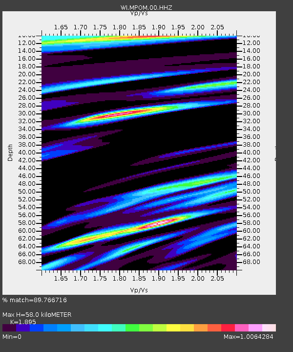
MPOM Morne Pois, Sainte-Anne, Martinique - Earthquake Result Viewer
| Earthquake location: |
Central Mid-Atlantic Ridge |
| Earthquake latitude/longitude: |
-1.1/-23.5 |
| Earthquake time(UTC): |
2017/11/30 (334) 06:32:52 GMT |
| Earthquake Depth: |
10 km |
| Earthquake Magnitude: |
6.5 Mi |
| Earthquake Catalog/Contributor: |
NEIC PDE/at |
|
| Network: |
WI West Indies IPGP Network |
| Station: |
MPOM Morne Pois, Sainte-Anne, Martinique |
| Lat/Lon: |
14.45 N/60.86 W |
| Elevation: |
50 m |
|
| Distance: |
40.1 deg |
| Az: |
294.067 deg |
| Baz: |
109.555 deg |
| Ray Param: |
0.074601956 |
| Estimated Moho Depth: |
58.0 km |
| Estimated Crust Vp/Vs: |
1.89 |
| Assumed Crust Vp: |
5.88 km/s |
| Estimated Crust Vs: |
3.103 km/s |
| Estimated Crust Poisson's Ratio: |
0.31 |
|
| Radial Match: |
89.766716 % |
| Radial Bump: |
400 |
| Transverse Match: |
67.403366 % |
| Transverse Bump: |
400 |
| SOD ConfigId: |
2429771 |
| Insert Time: |
2017-12-14 06:44:11.257 +0000 |
| GWidth: |
2.5 |
| Max Bumps: |
400 |
| Tol: |
0.001 |
|

Signal To Noise
| Channel | StoN | STA | LTA |
| WI:MPOM:00:HHZ:20171130T06:39:56.600006Z | 9.579909 | 3.98986E-6 | 4.1648204E-7 |
| WI:MPOM:00:HHN:20171130T06:39:56.600006Z | 2.9963293 | 1.0833588E-6 | 3.61562E-7 |
| WI:MPOM:00:HHE:20171130T06:39:56.600006Z | 6.565888 | 2.5419056E-6 | 3.8713813E-7 |
| Arrivals |
| Ps | 9.3 SECOND |
| PpPs | 27 SECOND |
| PsPs/PpSs | 36 SECOND |


