You are here: Home > Network List > WY - Yellowstone Wyoming Seismic Network Stations List
> Station YHR Hawk's Rest, WY, USA > Earthquake Result Viewer
YHR Hawk's Rest, WY, USA - Earthquake Result Viewer
*The percent match for this event was below the threshold and hence no stack was calculated.
| Earthquake location: |
Central Mid-Atlantic Ridge |
| Earthquake latitude/longitude: |
-1.1/-23.5 |
| Earthquake time(UTC): |
2017/11/30 (334) 06:32:52 GMT |
| Earthquake Depth: |
10 km |
| Earthquake Magnitude: |
6.5 Mi |
| Earthquake Catalog/Contributor: |
NEIC PDE/at |
|
| Network: |
WY Yellowstone Wyoming Seismic Network |
| Station: |
YHR Hawk's Rest, WY, USA |
| Lat/Lon: |
44.11 N/110.08 W |
| Elevation: |
2976 m |
|
| Distance: |
88.3 deg |
| Az: |
313.993 deg |
| Baz: |
93.159 deg |
| Ray Param: |
$rayparam |
*The percent match for this event was below the threshold and hence was not used in the summary stack. |
|
| Radial Match: |
79.85638 % |
| Radial Bump: |
400 |
| Transverse Match: |
56.967064 % |
| Transverse Bump: |
400 |
| SOD ConfigId: |
2429771 |
| Insert Time: |
2017-12-14 06:44:24.112 +0000 |
| GWidth: |
2.5 |
| Max Bumps: |
400 |
| Tol: |
0.001 |
|
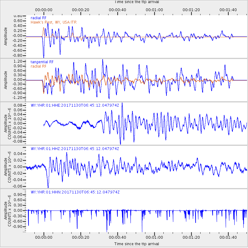
Signal To Noise
| Channel | StoN | STA | LTA |
| WY:YHR:01:HHZ:20171130T06:45:12.047974Z | 5.147682 | 2.5292342E-8 | 4.913346E-9 |
| WY:YHR:01:HHN:20171130T06:45:12.047974Z | 0.7965978 | 1.03996754E-7 | 1.3055116E-7 |
| WY:YHR:01:HHE:20171130T06:45:12.047974Z | 2.7292073 | 2.4447173E-8 | 8.95761E-9 |
| Arrivals |
| Ps | |
| PpPs | |
| PsPs/PpSs | |


