You are here: Home > Network List > KZ - Kazakhstan Network Stations List
> Station ABKAR Akbulak array,AB31, Kazakhstan > Earthquake Result Viewer
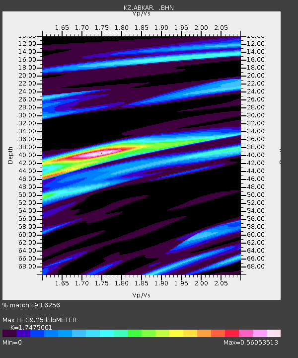
ABKAR Akbulak array,AB31, Kazakhstan - Earthquake Result Viewer
| Earthquake location: |
Southern Sumatra, Indonesia |
| Earthquake latitude/longitude: |
-2.1/99.6 |
| Earthquake time(UTC): |
2007/09/13 (256) 03:35:28 GMT |
| Earthquake Depth: |
22 km |
| Earthquake Magnitude: |
6.3 MB, 7.2 MS, 7.0 MW, 7.1 ME |
| Earthquake Catalog/Contributor: |
WHDF/NEIC |
|
| Network: |
KZ Kazakhstan Network |
| Station: |
ABKAR Akbulak array,AB31, Kazakhstan |
| Lat/Lon: |
49.26 N/59.94 E |
| Elevation: |
362 m |
|
| Distance: |
61.6 deg |
| Az: |
331.593 deg |
| Baz: |
133.482 deg |
| Ray Param: |
0.06075914 |
| Estimated Moho Depth: |
39.25 km |
| Estimated Crust Vp/Vs: |
1.75 |
| Assumed Crust Vp: |
6.35 km/s |
| Estimated Crust Vs: |
3.634 km/s |
| Estimated Crust Poisson's Ratio: |
0.26 |
|
| Radial Match: |
98.6256 % |
| Radial Bump: |
265 |
| Transverse Match: |
94.09484 % |
| Transverse Bump: |
400 |
| SOD ConfigId: |
2564 |
| Insert Time: |
2010-03-09 08:26:43.091 +0000 |
| GWidth: |
2.5 |
| Max Bumps: |
400 |
| Tol: |
0.001 |
|

Signal To Noise
| Channel | StoN | STA | LTA |
| KZ:ABKAR: :BHN:20070913T03:45:13.225005Z | 4.9844813 | 1.4164609E-6 | 2.8417418E-7 |
| KZ:ABKAR: :BHE:20070913T03:45:13.225005Z | 24.410748 | 2.7248045E-6 | 1.1162315E-7 |
| KZ:ABKAR: :BHZ:20070913T03:45:13.225005Z | 26.673864 | 5.8033706E-6 | 2.1756769E-7 |
| Arrivals |
| Ps | 4.8 SECOND |
| PpPs | 16 SECOND |
| PsPs/PpSs | 21 SECOND |


