You are here: Home > Network List > CO - South Carolina Seismic Network Stations List
> Station CASEE Lake Jocassee, SC, USA > Earthquake Result Viewer
CASEE Lake Jocassee, SC, USA - Earthquake Result Viewer
| Earthquake location: |
Southern East Pacific Rise |
| Earthquake latitude/longitude: |
-33.1/-109.4 |
| Earthquake time(UTC): |
2021/05/19 (139) 00:42:19 GMT |
| Earthquake Depth: |
10 km |
| Earthquake Magnitude: |
6.7 mww |
| Earthquake Catalog/Contributor: |
NEIC PDE/us |
|
| Network: |
CO South Carolina Seismic Network |
| Station: |
CASEE Lake Jocassee, SC, USA |
| Lat/Lon: |
34.99 N/82.93 W |
| Elevation: |
385 m |
|
| Distance: |
72.1 deg |
| Az: |
22.61 deg |
| Baz: |
203.154 deg |
| Ray Param: |
0.053887106 |
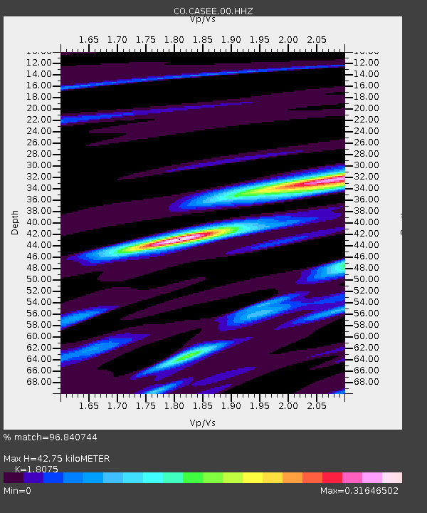
| Estimated Moho Depth: |
42.75 km |
| Estimated Crust Vp/Vs: |
1.81 |
| Assumed Crust Vp: |
6.35 km/s |
| Estimated Crust Vs: |
3.513 km/s |
| Estimated Crust Poisson's Ratio: |
0.28 |
|
| Radial Match: |
96.840744 % |
| Radial Bump: |
168 |
| Transverse Match: |
77.11904 % |
| Transverse Bump: |
400 |
| SOD ConfigId: |
24890451 |
| Insert Time: |
2021-06-02 18:08:40.334 +0000 |
| GWidth: |
2.5 |
| Max Bumps: |
400 |
| Tol: |
0.001 |
|

Signal To Noise
| Channel | StoN | STA | LTA |
| CO:CASEE:00:HHZ:20210519T00:53:12.878002Z | 4.6512513 | 4.6269056E-7 | 9.947658E-8 |
| CO:CASEE:00:HHN:20210519T00:53:12.878002Z | 2.1241693 | 1.6186988E-7 | 7.620385E-8 |
| CO:CASEE:00:HHE:20210519T00:53:12.878002Z | 1.3966478 | 9.538372E-8 | 6.829475E-8 |
| Arrivals |
| Ps | 5.6 SECOND |
| PpPs | 18 SECOND |
| PsPs/PpSs | 24 SECOND |


