You are here: Home > Network List > CU - Caribbean Network (USGS) Stations List
> Station GTBY Guantanamo Bay, Cuba > Earthquake Result Viewer
GTBY Guantanamo Bay, Cuba - Earthquake Result Viewer
| Earthquake location: |
Southern East Pacific Rise |
| Earthquake latitude/longitude: |
-33.1/-109.4 |
| Earthquake time(UTC): |
2021/05/19 (139) 00:42:19 GMT |
| Earthquake Depth: |
10 km |
| Earthquake Magnitude: |
6.7 mww |
| Earthquake Catalog/Contributor: |
NEIC PDE/us |
|
| Network: |
CU Caribbean Network (USGS) |
| Station: |
GTBY Guantanamo Bay, Cuba |
| Lat/Lon: |
19.93 N/75.11 W |
| Elevation: |
79 m |
|
| Distance: |
62.0 deg |
| Az: |
36.87 deg |
| Baz: |
212.378 deg |
| Ray Param: |
0.060491398 |
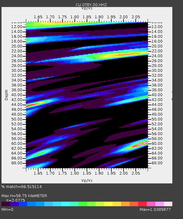
| Estimated Moho Depth: |
59.75 km |
| Estimated Crust Vp/Vs: |
2.08 |
| Assumed Crust Vp: |
6.048 km/s |
| Estimated Crust Vs: |
2.911 km/s |
| Estimated Crust Poisson's Ratio: |
0.35 |
|
| Radial Match: |
86.515114 % |
| Radial Bump: |
400 |
| Transverse Match: |
61.35026 % |
| Transverse Bump: |
400 |
| SOD ConfigId: |
24890451 |
| Insert Time: |
2021-06-02 18:08:51.218 +0000 |
| GWidth: |
2.5 |
| Max Bumps: |
400 |
| Tol: |
0.001 |
|
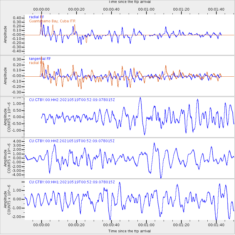
Signal To Noise
| Channel | StoN | STA | LTA |
| CU:GTBY:00:HHZ:20210519T00:52:09.078015Z | 3.450066 | 1.3241751E-6 | 3.8381148E-7 |
| CU:GTBY:00:HH1:20210519T00:52:09.078015Z | 1.5762315 | 4.6099225E-7 | 2.9246482E-7 |
| CU:GTBY:00:HH2:20210519T00:52:09.078015Z | 1.6927875 | 3.103818E-7 | 1.8335544E-7 |
| Arrivals |
| Ps | 11 SECOND |
| PpPs | 29 SECOND |
| PsPs/PpSs | 40 SECOND |


