You are here: Home > Network List > GS - US Geological Survey Networks Stations List
> Station PR01 PR01, Lajas > Earthquake Result Viewer
PR01 PR01, Lajas - Earthquake Result Viewer
| Earthquake location: |
Southern East Pacific Rise |
| Earthquake latitude/longitude: |
-33.1/-109.4 |
| Earthquake time(UTC): |
2021/05/19 (139) 00:42:19 GMT |
| Earthquake Depth: |
10 km |
| Earthquake Magnitude: |
6.7 mww |
| Earthquake Catalog/Contributor: |
NEIC PDE/us |
|
| Network: |
GS US Geological Survey Networks |
| Station: |
PR01 PR01, Lajas |
| Lat/Lon: |
18.03 N/67.07 W |
| Elevation: |
33 m |
|
| Distance: |
64.9 deg |
| Az: |
45.014 deg |
| Baz: |
218.624 deg |
| Ray Param: |
0.05860503 |
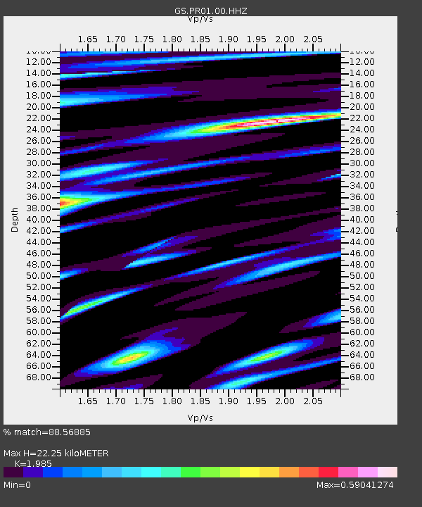
| Estimated Moho Depth: |
22.25 km |
| Estimated Crust Vp/Vs: |
1.99 |
| Assumed Crust Vp: |
5.14 km/s |
| Estimated Crust Vs: |
2.589 km/s |
| Estimated Crust Poisson's Ratio: |
0.33 |
|
| Radial Match: |
88.56885 % |
| Radial Bump: |
400 |
| Transverse Match: |
87.95964 % |
| Transverse Bump: |
400 |
| SOD ConfigId: |
24890451 |
| Insert Time: |
2021-06-02 18:10:03.535 +0000 |
| GWidth: |
2.5 |
| Max Bumps: |
400 |
| Tol: |
0.001 |
|

Signal To Noise
| Channel | StoN | STA | LTA |
| GS:PR01:00:HHZ:20210519T00:52:28.183972Z | 4.767647 | 9.174101E-7 | 1.924241E-7 |
| GS:PR01:00:HH1:20210519T00:52:28.183972Z | 1.7124511 | 2.663137E-7 | 1.5551608E-7 |
| GS:PR01:00:HH2:20210519T00:52:28.183972Z | 2.0721066 | 3.0926455E-7 | 1.4925126E-7 |
| Arrivals |
| Ps | 4.4 SECOND |
| PpPs | 13 SECOND |
| PsPs/PpSs | 17 SECOND |


