You are here: Home > Network List > MB - Montana Regional Seismic Network Stations List
> Station LDM Little Jackson Creek seismic vault > Earthquake Result Viewer
LDM Little Jackson Creek seismic vault - Earthquake Result Viewer
| Earthquake location: |
Southern East Pacific Rise |
| Earthquake latitude/longitude: |
-33.1/-109.4 |
| Earthquake time(UTC): |
2021/05/19 (139) 00:42:19 GMT |
| Earthquake Depth: |
10 km |
| Earthquake Magnitude: |
6.7 mww |
| Earthquake Catalog/Contributor: |
NEIC PDE/us |
|
| Network: |
MB Montana Regional Seismic Network |
| Station: |
LDM Little Jackson Creek seismic vault |
| Lat/Lon: |
48.45 N/115.32 W |
| Elevation: |
840 m |
|
| Distance: |
81.3 deg |
| Az: |
356.014 deg |
| Baz: |
174.97 deg |
| Ray Param: |
0.047673047 |
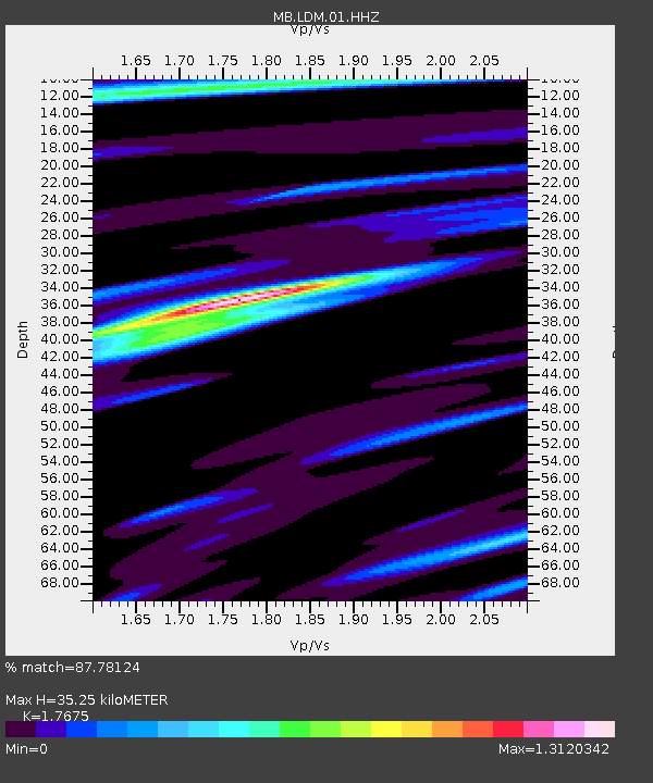
| Estimated Moho Depth: |
35.25 km |
| Estimated Crust Vp/Vs: |
1.77 |
| Assumed Crust Vp: |
6.622 km/s |
| Estimated Crust Vs: |
3.747 km/s |
| Estimated Crust Poisson's Ratio: |
0.26 |
|
| Radial Match: |
87.78124 % |
| Radial Bump: |
400 |
| Transverse Match: |
91.76411 % |
| Transverse Bump: |
400 |
| SOD ConfigId: |
24890451 |
| Insert Time: |
2021-06-02 18:11:35.926 +0000 |
| GWidth: |
2.5 |
| Max Bumps: |
400 |
| Tol: |
0.001 |
|

Signal To Noise
| Channel | StoN | STA | LTA |
| MB:LDM:01:HHZ:20210519T00:54:04.76997Z | 2.8273168 | 3.8211408E-7 | 1.3515078E-7 |
| MB:LDM:01:HHN:20210519T00:54:04.76997Z | 1.6843084 | 2.1836844E-7 | 1.2964873E-7 |
| MB:LDM:01:HHE:20210519T00:54:04.76997Z | 1.3268777 | 1.14519224E-7 | 8.6307296E-8 |
| Arrivals |
| Ps | 4.2 SECOND |
| PpPs | 14 SECOND |
| PsPs/PpSs | 19 SECOND |


