You are here: Home > Network List > MB - Montana Regional Seismic Network Stations List
> Station SRMT Salmond Ranch > Earthquake Result Viewer
SRMT Salmond Ranch - Earthquake Result Viewer
| Earthquake location: |
Southern East Pacific Rise |
| Earthquake latitude/longitude: |
-33.1/-109.4 |
| Earthquake time(UTC): |
2021/05/19 (139) 00:42:19 GMT |
| Earthquake Depth: |
10 km |
| Earthquake Magnitude: |
6.7 mww |
| Earthquake Catalog/Contributor: |
NEIC PDE/us |
|
| Network: |
MB Montana Regional Seismic Network |
| Station: |
SRMT Salmond Ranch |
| Lat/Lon: |
47.78 N/112.61 W |
| Elevation: |
1522 m |
|
| Distance: |
80.5 deg |
| Az: |
357.803 deg |
| Baz: |
177.265 deg |
| Ray Param: |
0.048218112 |
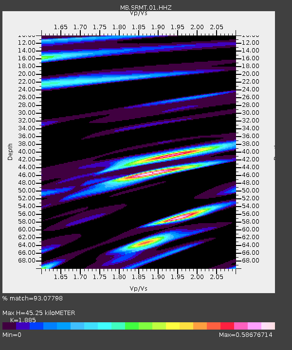
| Estimated Moho Depth: |
45.25 km |
| Estimated Crust Vp/Vs: |
1.88 |
| Assumed Crust Vp: |
6.353 km/s |
| Estimated Crust Vs: |
3.37 km/s |
| Estimated Crust Poisson's Ratio: |
0.30 |
|
| Radial Match: |
93.07798 % |
| Radial Bump: |
355 |
| Transverse Match: |
64.89363 % |
| Transverse Bump: |
400 |
| SOD ConfigId: |
24890451 |
| Insert Time: |
2021-06-02 18:11:38.783 +0000 |
| GWidth: |
2.5 |
| Max Bumps: |
400 |
| Tol: |
0.001 |
|

Signal To Noise
| Channel | StoN | STA | LTA |
| MB:SRMT:01:HHZ:20210519T00:54:00.51997Z | 2.3340912 | 1.8273109E-7 | 7.82879E-8 |
| MB:SRMT:01:HHN:20210519T00:54:00.51997Z | 1.4410752 | 9.561999E-8 | 6.635322E-8 |
| MB:SRMT:01:HHE:20210519T00:54:00.51997Z | 1.4690539 | 1.3845893E-7 | 9.42504E-8 |
| Arrivals |
| Ps | 6.5 SECOND |
| PpPs | 20 SECOND |
| PsPs/PpSs | 26 SECOND |


