You are here: Home > Network List > N4 - Central and EAstern US Network Stations List
> Station I42A Draeger Farm, Ripon, WI, USA > Earthquake Result Viewer
I42A Draeger Farm, Ripon, WI, USA - Earthquake Result Viewer
| Earthquake location: |
Southern East Pacific Rise |
| Earthquake latitude/longitude: |
-33.1/-109.4 |
| Earthquake time(UTC): |
2021/05/19 (139) 00:42:19 GMT |
| Earthquake Depth: |
10 km |
| Earthquake Magnitude: |
6.7 mww |
| Earthquake Catalog/Contributor: |
NEIC PDE/us |
|
| Network: |
N4 Central and EAstern US Network |
| Station: |
I42A Draeger Farm, Ripon, WI, USA |
| Lat/Lon: |
43.89 N/88.91 W |
| Elevation: |
298 m |
|
| Distance: |
78.8 deg |
| Az: |
14.942 deg |
| Baz: |
197.426 deg |
| Ray Param: |
0.049373668 |
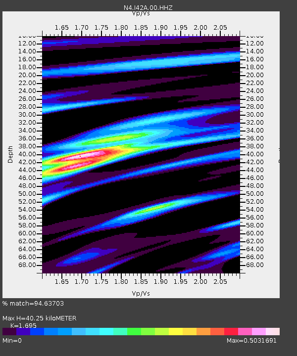
| Estimated Moho Depth: |
40.25 km |
| Estimated Crust Vp/Vs: |
1.70 |
| Assumed Crust Vp: |
6.571 km/s |
| Estimated Crust Vs: |
3.876 km/s |
| Estimated Crust Poisson's Ratio: |
0.23 |
|
| Radial Match: |
94.63703 % |
| Radial Bump: |
339 |
| Transverse Match: |
71.562386 % |
| Transverse Bump: |
400 |
| SOD ConfigId: |
24890451 |
| Insert Time: |
2021-06-02 18:12:15.624 +0000 |
| GWidth: |
2.5 |
| Max Bumps: |
400 |
| Tol: |
0.001 |
|

Signal To Noise
| Channel | StoN | STA | LTA |
| N4:I42A:00:HHZ:20210519T00:53:51.390026Z | 4.6965055 | 4.1323963E-7 | 8.798875E-8 |
| N4:I42A:00:HH1:20210519T00:53:51.390026Z | 2.395532 | 1.5140142E-7 | 6.320159E-8 |
| N4:I42A:00:HH2:20210519T00:53:51.390026Z | 1.1227623 | 7.922143E-8 | 7.05594E-8 |
| Arrivals |
| Ps | 4.4 SECOND |
| PpPs | 16 SECOND |
| PsPs/PpSs | 20 SECOND |


