You are here: Home > Network List > G - GEOSCOPE Stations List
> Station CLF Chambon la Foret observatory, France > Earthquake Result Viewer
CLF Chambon la Foret observatory, France - Earthquake Result Viewer
| Earthquake location: |
Northern And Central Iran |
| Earthquake latitude/longitude: |
30.7/57.3 |
| Earthquake time(UTC): |
2017/12/01 (335) 02:32:46 GMT |
| Earthquake Depth: |
9.0 km |
| Earthquake Magnitude: |
6.1 Mww |
| Earthquake Catalog/Contributor: |
NEIC PDE/us |
|
| Network: |
G GEOSCOPE |
| Station: |
CLF Chambon la Foret observatory, France |
| Lat/Lon: |
48.03 N/2.26 E |
| Elevation: |
145 m |
|
| Distance: |
44.9 deg |
| Az: |
308.811 deg |
| Baz: |
91.955 deg |
| Ray Param: |
0.07162135 |
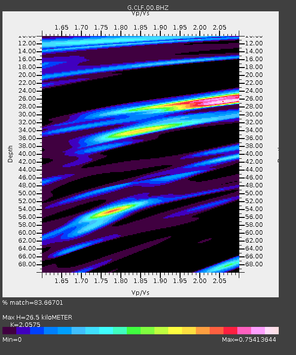
| Estimated Moho Depth: |
26.5 km |
| Estimated Crust Vp/Vs: |
2.06 |
| Assumed Crust Vp: |
6.12 km/s |
| Estimated Crust Vs: |
2.974 km/s |
| Estimated Crust Poisson's Ratio: |
0.35 |
|
| Radial Match: |
83.66701 % |
| Radial Bump: |
374 |
| Transverse Match: |
55.37321 % |
| Transverse Bump: |
379 |
| SOD ConfigId: |
2429771 |
| Insert Time: |
2017-12-15 02:33:21.813 +0000 |
| GWidth: |
2.5 |
| Max Bumps: |
400 |
| Tol: |
0.001 |
|

Signal To Noise
| Channel | StoN | STA | LTA |
| G:CLF:00:BHZ:20171201T02:40:30.098989Z | 6.7869396 | 4.7178987E-6 | 6.951438E-7 |
| G:CLF:00:BHN:20171201T02:40:30.098989Z | 1.6012684 | 8.489634E-7 | 5.301818E-7 |
| G:CLF:00:BHE:20171201T02:40:30.098989Z | 4.602444 | 2.5172817E-6 | 5.4694453E-7 |
| Arrivals |
| Ps | 4.8 SECOND |
| PpPs | 13 SECOND |
| PsPs/PpSs | 17 SECOND |


