You are here: Home > Network List > N4 - Central and EAstern US Network Stations List
> Station Q54A Coxs Mills, WV, USA > Earthquake Result Viewer
Q54A Coxs Mills, WV, USA - Earthquake Result Viewer
| Earthquake location: |
Southern East Pacific Rise |
| Earthquake latitude/longitude: |
-33.1/-109.4 |
| Earthquake time(UTC): |
2021/05/19 (139) 00:42:19 GMT |
| Earthquake Depth: |
10 km |
| Earthquake Magnitude: |
6.7 mww |
| Earthquake Catalog/Contributor: |
NEIC PDE/us |
|
| Network: |
N4 Central and EAstern US Network |
| Station: |
Q54A Coxs Mills, WV, USA |
| Lat/Lon: |
38.98 N/80.83 W |
| Elevation: |
254 m |
|
| Distance: |
76.4 deg |
| Az: |
22.539 deg |
| Baz: |
204.393 deg |
| Ray Param: |
0.051007066 |
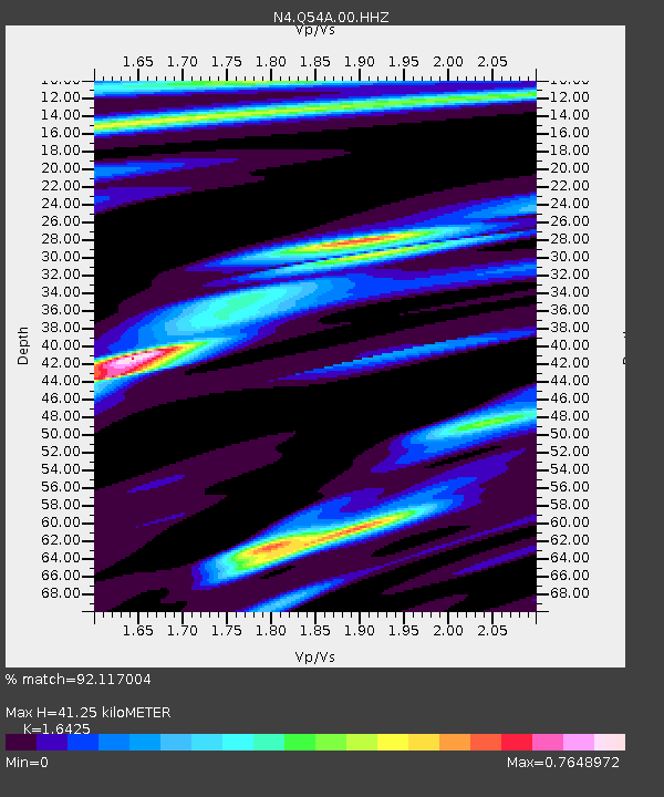
| Estimated Moho Depth: |
41.25 km |
| Estimated Crust Vp/Vs: |
1.64 |
| Assumed Crust Vp: |
6.207 km/s |
| Estimated Crust Vs: |
3.779 km/s |
| Estimated Crust Poisson's Ratio: |
0.21 |
|
| Radial Match: |
92.117004 % |
| Radial Bump: |
400 |
| Transverse Match: |
78.93333 % |
| Transverse Bump: |
400 |
| SOD ConfigId: |
24890451 |
| Insert Time: |
2021-06-02 18:13:20.288 +0000 |
| GWidth: |
2.5 |
| Max Bumps: |
400 |
| Tol: |
0.001 |
|

Signal To Noise
| Channel | StoN | STA | LTA |
| N4:Q54A:00:HHZ:20210519T00:53:38.008984Z | 3.5737486 | 4.1040923E-7 | 1.14839985E-7 |
| N4:Q54A:00:HH1:20210519T00:53:38.008984Z | 1.0975944 | 1.3549415E-7 | 1.2344648E-7 |
| N4:Q54A:00:HH2:20210519T00:53:38.008984Z | 0.730328 | 7.922968E-8 | 1.0848506E-7 |
| Arrivals |
| Ps | 4.4 SECOND |
| PpPs | 17 SECOND |
| PsPs/PpSs | 21 SECOND |


