You are here: Home > Network List > N4 - Central and EAstern US Network Stations List
> Station S44A Carbondale, IL, USA > Earthquake Result Viewer
S44A Carbondale, IL, USA - Earthquake Result Viewer
| Earthquake location: |
Southern East Pacific Rise |
| Earthquake latitude/longitude: |
-33.1/-109.4 |
| Earthquake time(UTC): |
2021/05/19 (139) 00:42:19 GMT |
| Earthquake Depth: |
10 km |
| Earthquake Magnitude: |
6.7 mww |
| Earthquake Catalog/Contributor: |
NEIC PDE/us |
|
| Network: |
N4 Central and EAstern US Network |
| Station: |
S44A Carbondale, IL, USA |
| Lat/Lon: |
37.69 N/89.26 W |
| Elevation: |
155 m |
|
| Distance: |
72.9 deg |
| Az: |
16.608 deg |
| Baz: |
197.612 deg |
| Ray Param: |
0.05339776 |
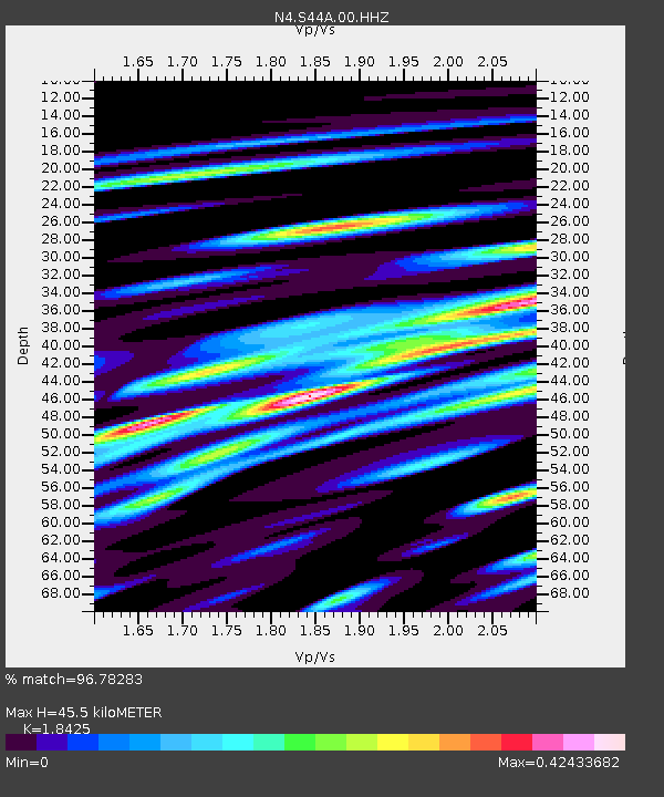
| Estimated Moho Depth: |
45.5 km |
| Estimated Crust Vp/Vs: |
1.84 |
| Assumed Crust Vp: |
6.444 km/s |
| Estimated Crust Vs: |
3.497 km/s |
| Estimated Crust Poisson's Ratio: |
0.29 |
|
| Radial Match: |
96.78283 % |
| Radial Bump: |
400 |
| Transverse Match: |
74.75821 % |
| Transverse Bump: |
400 |
| SOD ConfigId: |
24890451 |
| Insert Time: |
2021-06-02 18:13:31.580 +0000 |
| GWidth: |
2.5 |
| Max Bumps: |
400 |
| Tol: |
0.001 |
|

Signal To Noise
| Channel | StoN | STA | LTA |
| N4:S44A:00:HHZ:20210519T00:53:17.320019Z | 12.451669 | 5.603066E-7 | 4.4998515E-8 |
| N4:S44A:00:HH1:20210519T00:53:17.320019Z | 2.0450764 | 2.3295263E-7 | 1.1390902E-7 |
| N4:S44A:00:HH2:20210519T00:53:17.320019Z | 1.4320108 | 1.05196214E-7 | 7.3460484E-8 |
| Arrivals |
| Ps | 6.2 SECOND |
| PpPs | 19 SECOND |
| PsPs/PpSs | 26 SECOND |


