You are here: Home > Network List > N4 - Central and EAstern US Network Stations List
> Station SPMN Marine on St. Croix, MN, USA > Earthquake Result Viewer
SPMN Marine on St. Croix, MN, USA - Earthquake Result Viewer
| Earthquake location: |
Southern East Pacific Rise |
| Earthquake latitude/longitude: |
-33.1/-109.4 |
| Earthquake time(UTC): |
2021/05/19 (139) 00:42:19 GMT |
| Earthquake Depth: |
10 km |
| Earthquake Magnitude: |
6.7 mww |
| Earthquake Catalog/Contributor: |
NEIC PDE/us |
|
| Network: |
N4 Central and EAstern US Network |
| Station: |
SPMN Marine on St. Croix, MN, USA |
| Lat/Lon: |
45.22 N/92.80 W |
| Elevation: |
311 m |
|
| Distance: |
79.4 deg |
| Az: |
11.848 deg |
| Baz: |
194.12 deg |
| Ray Param: |
0.0490168 |
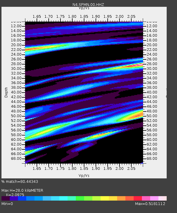
| Estimated Moho Depth: |
28.0 km |
| Estimated Crust Vp/Vs: |
2.10 |
| Assumed Crust Vp: |
6.571 km/s |
| Estimated Crust Vs: |
3.133 km/s |
| Estimated Crust Poisson's Ratio: |
0.35 |
|
| Radial Match: |
80.44343 % |
| Radial Bump: |
400 |
| Transverse Match: |
64.11044 % |
| Transverse Bump: |
400 |
| SOD ConfigId: |
24890451 |
| Insert Time: |
2021-06-02 18:13:37.628 +0000 |
| GWidth: |
2.5 |
| Max Bumps: |
400 |
| Tol: |
0.001 |
|

Signal To Noise
| Channel | StoN | STA | LTA |
| N4:SPMN:00:HHZ:20210519T00:53:54.26997Z | 5.4983816 | 4.782784E-7 | 8.698531E-8 |
| N4:SPMN:00:HH1:20210519T00:53:54.26997Z | 1.346156 | 1.9399292E-7 | 1.4410878E-7 |
| N4:SPMN:00:HH2:20210519T00:53:54.26997Z | 0.4944469 | 1.0718428E-7 | 2.167761E-7 |
| Arrivals |
| Ps | 4.8 SECOND |
| PpPs | 13 SECOND |
| PsPs/PpSs | 18 SECOND |


