You are here: Home > Network List > N4 - Central and EAstern US Network Stations List
> Station T35B Sooner Cattle Company, Foraker, OK, USA > Earthquake Result Viewer
T35B Sooner Cattle Company, Foraker, OK, USA - Earthquake Result Viewer
| Earthquake location: |
Southern East Pacific Rise |
| Earthquake latitude/longitude: |
-33.1/-109.4 |
| Earthquake time(UTC): |
2021/05/19 (139) 00:42:19 GMT |
| Earthquake Depth: |
10 km |
| Earthquake Magnitude: |
6.7 mww |
| Earthquake Catalog/Contributor: |
NEIC PDE/us |
|
| Network: |
N4 Central and EAstern US Network |
| Station: |
T35B Sooner Cattle Company, Foraker, OK, USA |
| Lat/Lon: |
36.92 N/96.51 W |
| Elevation: |
413 m |
|
| Distance: |
70.7 deg |
| Az: |
10.916 deg |
| Baz: |
191.445 deg |
| Ray Param: |
0.054854076 |
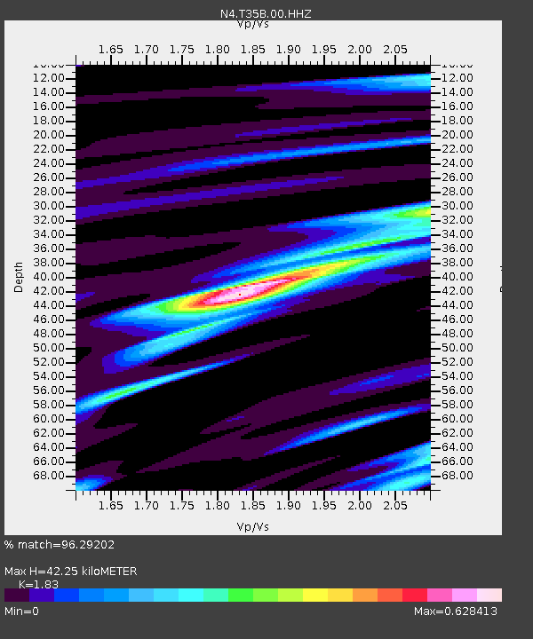
| Estimated Moho Depth: |
42.25 km |
| Estimated Crust Vp/Vs: |
1.83 |
| Assumed Crust Vp: |
6.483 km/s |
| Estimated Crust Vs: |
3.542 km/s |
| Estimated Crust Poisson's Ratio: |
0.29 |
|
| Radial Match: |
96.29202 % |
| Radial Bump: |
400 |
| Transverse Match: |
70.08412 % |
| Transverse Bump: |
400 |
| SOD ConfigId: |
24890451 |
| Insert Time: |
2021-06-02 18:13:40.562 +0000 |
| GWidth: |
2.5 |
| Max Bumps: |
400 |
| Tol: |
0.001 |
|

Signal To Noise
| Channel | StoN | STA | LTA |
| N4:T35B:00:HHZ:20210519T00:53:04.109021Z | 5.7588873 | 3.9320224E-7 | 6.8277465E-8 |
| N4:T35B:00:HH1:20210519T00:53:04.109021Z | 2.63445 | 1.7520267E-7 | 6.6504455E-8 |
| N4:T35B:00:HH2:20210519T00:53:04.109021Z | 2.1997828 | 1.2599911E-7 | 5.7277976E-8 |
| Arrivals |
| Ps | 5.6 SECOND |
| PpPs | 18 SECOND |
| PsPs/PpSs | 23 SECOND |


