You are here: Home > Network List > N4 - Central and EAstern US Network Stations List
> Station U56A King, NC, USA > Earthquake Result Viewer
U56A King, NC, USA - Earthquake Result Viewer
| Earthquake location: |
Southern East Pacific Rise |
| Earthquake latitude/longitude: |
-33.1/-109.4 |
| Earthquake time(UTC): |
2021/05/19 (139) 00:42:19 GMT |
| Earthquake Depth: |
10 km |
| Earthquake Magnitude: |
6.7 mww |
| Earthquake Catalog/Contributor: |
NEIC PDE/us |
|
| Network: |
N4 Central and EAstern US Network |
| Station: |
U56A King, NC, USA |
| Lat/Lon: |
36.35 N/80.38 W |
| Elevation: |
363 m |
|
| Distance: |
74.2 deg |
| Az: |
24.013 deg |
| Baz: |
205.041 deg |
| Ray Param: |
0.052513774 |
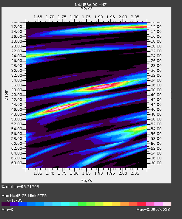
| Estimated Moho Depth: |
45.25 km |
| Estimated Crust Vp/Vs: |
1.74 |
| Assumed Crust Vp: |
6.159 km/s |
| Estimated Crust Vs: |
3.55 km/s |
| Estimated Crust Poisson's Ratio: |
0.25 |
|
| Radial Match: |
96.21708 % |
| Radial Bump: |
400 |
| Transverse Match: |
66.17183 % |
| Transverse Bump: |
400 |
| SOD ConfigId: |
24890451 |
| Insert Time: |
2021-06-02 18:13:54.877 +0000 |
| GWidth: |
2.5 |
| Max Bumps: |
400 |
| Tol: |
0.001 |
|

Signal To Noise
| Channel | StoN | STA | LTA |
| N4:U56A:00:HHZ:20210519T00:53:25.149975Z | 4.9078717 | 3.4109902E-7 | 6.9500395E-8 |
| N4:U56A:00:HH1:20210519T00:53:25.149975Z | 2.4901593 | 2.0691961E-7 | 8.309493E-8 |
| N4:U56A:00:HH2:20210519T00:53:25.149975Z | 1.0527068 | 9.782878E-8 | 9.29307E-8 |
| Arrivals |
| Ps | 5.6 SECOND |
| PpPs | 19 SECOND |
| PsPs/PpSs | 25 SECOND |


