You are here: Home > Network List > O2 - Oklahoma Consolidated Temporary Seismic Networks Stations List
> Station DOVR Dover, Oklahoma, USA > Earthquake Result Viewer
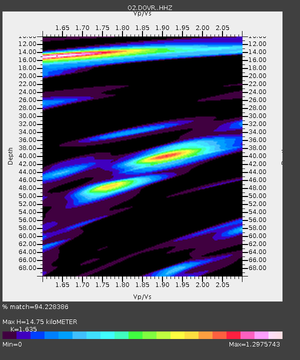
DOVR Dover, Oklahoma, USA - Earthquake Result Viewer
| Earthquake location: |
Southern East Pacific Rise |
| Earthquake latitude/longitude: |
-33.1/-109.4 |
| Earthquake time(UTC): |
2021/05/19 (139) 00:42:19 GMT |
| Earthquake Depth: |
10 km |
| Earthquake Magnitude: |
6.7 mww |
| Earthquake Catalog/Contributor: |
NEIC PDE/us |
|
| Network: |
O2 Oklahoma Consolidated Temporary Seismic Networks |
| Station: |
DOVR Dover, Oklahoma, USA |
| Lat/Lon: |
35.95 N/97.99 W |
| Elevation: |
337 m |
|
| Distance: |
69.5 deg |
| Az: |
9.865 deg |
| Baz: |
190.213 deg |
| Ray Param: |
0.05561707 |
| Estimated Moho Depth: |
14.75 km |
| Estimated Crust Vp/Vs: |
1.63 |
| Assumed Crust Vp: |
6.426 km/s |
| Estimated Crust Vs: |
3.93 km/s |
| Estimated Crust Poisson's Ratio: |
0.20 |
|
| Radial Match: |
94.228386 % |
| Radial Bump: |
328 |
| Transverse Match: |
79.404396 % |
| Transverse Bump: |
400 |
| SOD ConfigId: |
24890451 |
| Insert Time: |
2021-06-02 18:16:03.647 +0000 |
| GWidth: |
2.5 |
| Max Bumps: |
400 |
| Tol: |
0.001 |
|

Signal To Noise
| Channel | StoN | STA | LTA |
| O2:DOVR: :HHZ:20210519T00:52:56.964978Z | 7.308695 | 6.4564904E-7 | 8.833985E-8 |
| O2:DOVR: :HHN:20210519T00:52:56.964978Z | 1.1950912 | 1.8508882E-7 | 1.5487421E-7 |
| O2:DOVR: :HHE:20210519T00:52:56.964978Z | 1.2053714 | 1.5914539E-7 | 1.3203017E-7 |
| Arrivals |
| Ps | 1.5 SECOND |
| PpPs | 5.8 SECOND |
| PsPs/PpSs | 7.3 SECOND |


