You are here: Home > Network List > O2 - Oklahoma Consolidated Temporary Seismic Networks Stations List
> Station KS13 South Haven SW Station, Kansas > Earthquake Result Viewer
KS13 South Haven SW Station, Kansas - Earthquake Result Viewer
| Earthquake location: |
Southern East Pacific Rise |
| Earthquake latitude/longitude: |
-33.1/-109.4 |
| Earthquake time(UTC): |
2021/05/19 (139) 00:42:19 GMT |
| Earthquake Depth: |
10 km |
| Earthquake Magnitude: |
6.7 mww |
| Earthquake Catalog/Contributor: |
NEIC PDE/us |
|
| Network: |
O2 Oklahoma Consolidated Temporary Seismic Networks |
| Station: |
KS13 South Haven SW Station, Kansas |
| Lat/Lon: |
37.01 N/97.48 W |
| Elevation: |
340 m |
|
| Distance: |
70.6 deg |
| Az: |
10.092 deg |
| Baz: |
190.593 deg |
| Ray Param: |
0.054890253 |
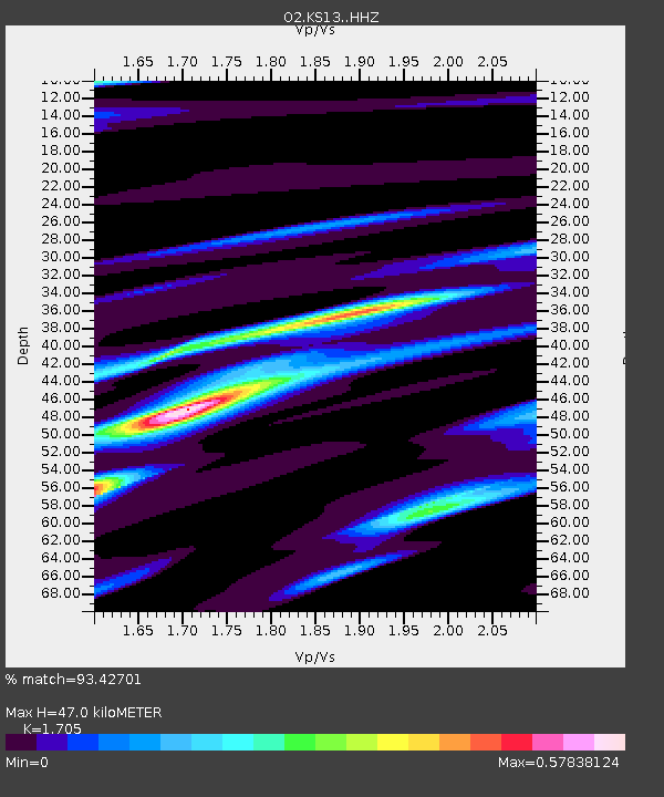
| Estimated Moho Depth: |
47.0 km |
| Estimated Crust Vp/Vs: |
1.71 |
| Assumed Crust Vp: |
6.483 km/s |
| Estimated Crust Vs: |
3.802 km/s |
| Estimated Crust Poisson's Ratio: |
0.24 |
|
| Radial Match: |
93.42701 % |
| Radial Bump: |
400 |
| Transverse Match: |
63.30181 % |
| Transverse Bump: |
400 |
| SOD ConfigId: |
24890451 |
| Insert Time: |
2021-06-02 18:16:24.321 +0000 |
| GWidth: |
2.5 |
| Max Bumps: |
400 |
| Tol: |
0.001 |
|

Signal To Noise
| Channel | StoN | STA | LTA |
| O2:KS13: :HHZ:20210519T00:53:03.77998Z | 5.1915565 | 6.5825867E-7 | 1.2679409E-7 |
| O2:KS13: :HHN:20210519T00:53:03.77998Z | 1.0500938 | 2.3232819E-7 | 2.2124519E-7 |
| O2:KS13: :HHE:20210519T00:53:03.77998Z | 1.4095867 | 2.6829846E-7 | 1.903384E-7 |
| Arrivals |
| Ps | 5.3 SECOND |
| PpPs | 19 SECOND |
| PsPs/PpSs | 24 SECOND |


