You are here: Home > Network List > O2 - Oklahoma Consolidated Temporary Seismic Networks Stations List
> Station MRSH Marshall, Oklahoma, USA > Earthquake Result Viewer
MRSH Marshall, Oklahoma, USA - Earthquake Result Viewer
| Earthquake location: |
Southern East Pacific Rise |
| Earthquake latitude/longitude: |
-33.1/-109.4 |
| Earthquake time(UTC): |
2021/05/19 (139) 00:42:19 GMT |
| Earthquake Depth: |
10 km |
| Earthquake Magnitude: |
6.7 mww |
| Earthquake Catalog/Contributor: |
NEIC PDE/us |
|
| Network: |
O2 Oklahoma Consolidated Temporary Seismic Networks |
| Station: |
MRSH Marshall, Oklahoma, USA |
| Lat/Lon: |
36.13 N/97.70 W |
| Elevation: |
309 m |
|
| Distance: |
69.7 deg |
| Az: |
10.08 deg |
| Baz: |
190.46 deg |
| Ray Param: |
0.05547223 |
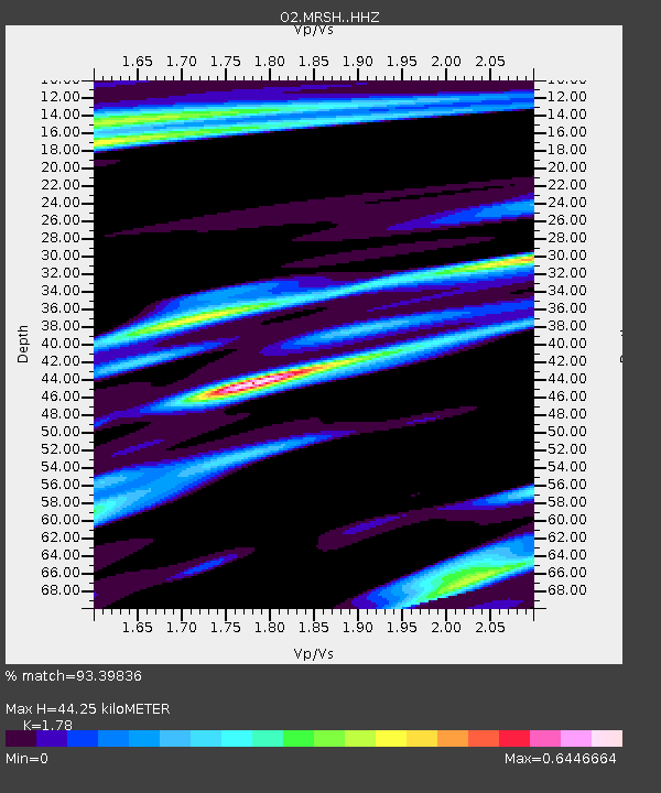
| Estimated Moho Depth: |
44.25 km |
| Estimated Crust Vp/Vs: |
1.78 |
| Assumed Crust Vp: |
6.483 km/s |
| Estimated Crust Vs: |
3.642 km/s |
| Estimated Crust Poisson's Ratio: |
0.27 |
|
| Radial Match: |
93.39836 % |
| Radial Bump: |
272 |
| Transverse Match: |
81.978485 % |
| Transverse Bump: |
400 |
| SOD ConfigId: |
24890451 |
| Insert Time: |
2021-06-02 18:16:25.444 +0000 |
| GWidth: |
2.5 |
| Max Bumps: |
400 |
| Tol: |
0.001 |
|

Signal To Noise
| Channel | StoN | STA | LTA |
| O2:MRSH: :HHZ:20210519T00:52:58.305004Z | 8.344298 | 7.1381953E-7 | 8.5545786E-8 |
| O2:MRSH: :HHN:20210519T00:52:58.305004Z | 2.0592763 | 2.673728E-7 | 1.2983824E-7 |
| O2:MRSH: :HHE:20210519T00:52:58.305004Z | 1.3327458 | 1.6027312E-7 | 1.2025784E-7 |
| Arrivals |
| Ps | 5.5 SECOND |
| PpPs | 18 SECOND |
| PsPs/PpSs | 24 SECOND |


