You are here: Home > Network List > O2 - Oklahoma Consolidated Temporary Seismic Networks Stations List
> Station PW09 Ralston, Oklahoma > Earthquake Result Viewer
PW09 Ralston, Oklahoma - Earthquake Result Viewer
| Earthquake location: |
Southern East Pacific Rise |
| Earthquake latitude/longitude: |
-33.1/-109.4 |
| Earthquake time(UTC): |
2021/05/19 (139) 00:42:19 GMT |
| Earthquake Depth: |
10 km |
| Earthquake Magnitude: |
6.7 mww |
| Earthquake Catalog/Contributor: |
NEIC PDE/us |
|
| Network: |
O2 Oklahoma Consolidated Temporary Seismic Networks |
| Station: |
PW09 Ralston, Oklahoma |
| Lat/Lon: |
36.45 N/96.82 W |
| Elevation: |
291 m |
|
| Distance: |
70.1 deg |
| Az: |
10.759 deg |
| Baz: |
191.21 deg |
| Ray Param: |
0.055192813 |
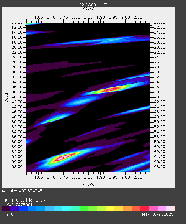
| Estimated Moho Depth: |
64.0 km |
| Estimated Crust Vp/Vs: |
1.75 |
| Assumed Crust Vp: |
6.483 km/s |
| Estimated Crust Vs: |
3.71 km/s |
| Estimated Crust Poisson's Ratio: |
0.26 |
|
| Radial Match: |
90.574745 % |
| Radial Bump: |
362 |
| Transverse Match: |
72.12468 % |
| Transverse Bump: |
400 |
| SOD ConfigId: |
24890451 |
| Insert Time: |
2021-06-02 18:16:33.958 +0000 |
| GWidth: |
2.5 |
| Max Bumps: |
400 |
| Tol: |
0.001 |
|

Signal To Noise
| Channel | StoN | STA | LTA |
| O2:PW09: :HHZ:20210519T00:53:01.015026Z | 6.082309 | 5.7530843E-7 | 9.458718E-8 |
| O2:PW09: :HHN:20210519T00:53:01.015026Z | 1.9768091 | 2.3590042E-7 | 1.1933393E-7 |
| O2:PW09: :HHE:20210519T00:53:01.015026Z | 1.7014658 | 1.2202699E-7 | 7.171874E-8 |
| Arrivals |
| Ps | 7.7 SECOND |
| PpPs | 26 SECOND |
| PsPs/PpSs | 34 SECOND |


