You are here: Home > Network List > O2 - Oklahoma Consolidated Temporary Seismic Networks Stations List
> Station PW10 Pawnee, Oklahoma > Earthquake Result Viewer
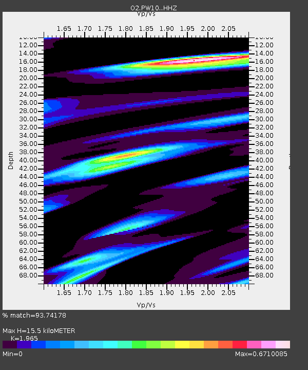
PW10 Pawnee, Oklahoma - Earthquake Result Viewer
| Earthquake location: |
Southern East Pacific Rise |
| Earthquake latitude/longitude: |
-33.1/-109.4 |
| Earthquake time(UTC): |
2021/05/19 (139) 00:42:19 GMT |
| Earthquake Depth: |
10 km |
| Earthquake Magnitude: |
6.7 mww |
| Earthquake Catalog/Contributor: |
NEIC PDE/us |
|
| Network: |
O2 Oklahoma Consolidated Temporary Seismic Networks |
| Station: |
PW10 Pawnee, Oklahoma |
| Lat/Lon: |
36.37 N/96.83 W |
| Elevation: |
297 m |
|
| Distance: |
70.1 deg |
| Az: |
10.764 deg |
| Baz: |
191.204 deg |
| Ray Param: |
0.055246484 |
| Estimated Moho Depth: |
15.5 km |
| Estimated Crust Vp/Vs: |
1.97 |
| Assumed Crust Vp: |
6.483 km/s |
| Estimated Crust Vs: |
3.299 km/s |
| Estimated Crust Poisson's Ratio: |
0.33 |
|
| Radial Match: |
93.74178 % |
| Radial Bump: |
316 |
| Transverse Match: |
84.122444 % |
| Transverse Bump: |
400 |
| SOD ConfigId: |
24890451 |
| Insert Time: |
2021-06-02 18:16:36.447 +0000 |
| GWidth: |
2.5 |
| Max Bumps: |
400 |
| Tol: |
0.001 |
|

Signal To Noise
| Channel | StoN | STA | LTA |
| O2:PW10: :HHZ:20210519T00:53:00.510021Z | 5.828726 | 5.7110316E-7 | 9.7980795E-8 |
| O2:PW10: :HHN:20210519T00:53:00.510021Z | 3.1664565 | 2.0713551E-7 | 6.5415556E-8 |
| O2:PW10: :HHE:20210519T00:53:00.510021Z | 1.2494533 | 9.52647E-8 | 7.624511E-8 |
| Arrivals |
| Ps | 2.4 SECOND |
| PpPs | 6.9 SECOND |
| PsPs/PpSs | 9.2 SECOND |


