You are here: Home > Network List > OK - Oklahoma Seismic Network Stations List
> Station CHOK Chandler, Oklahoma, USA > Earthquake Result Viewer
CHOK Chandler, Oklahoma, USA - Earthquake Result Viewer
| Earthquake location: |
Southern East Pacific Rise |
| Earthquake latitude/longitude: |
-33.1/-109.4 |
| Earthquake time(UTC): |
2021/05/19 (139) 00:42:19 GMT |
| Earthquake Depth: |
10 km |
| Earthquake Magnitude: |
6.7 mww |
| Earthquake Catalog/Contributor: |
NEIC PDE/us |
|
| Network: |
OK Oklahoma Seismic Network |
| Station: |
CHOK Chandler, Oklahoma, USA |
| Lat/Lon: |
35.56 N/97.06 W |
| Elevation: |
338 m |
|
| Distance: |
69.2 deg |
| Az: |
10.734 deg |
| Baz: |
191.059 deg |
| Ray Param: |
0.055781182 |
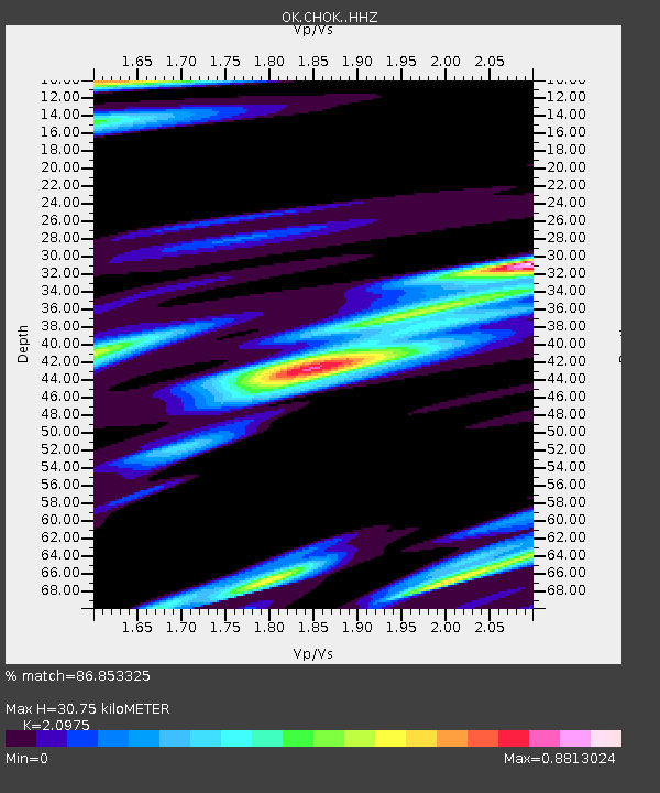
| Estimated Moho Depth: |
30.75 km |
| Estimated Crust Vp/Vs: |
2.10 |
| Assumed Crust Vp: |
6.426 km/s |
| Estimated Crust Vs: |
3.064 km/s |
| Estimated Crust Poisson's Ratio: |
0.35 |
|
| Radial Match: |
86.853325 % |
| Radial Bump: |
400 |
| Transverse Match: |
49.607758 % |
| Transverse Bump: |
400 |
| SOD ConfigId: |
24890451 |
| Insert Time: |
2021-06-02 18:17:47.802 +0000 |
| GWidth: |
2.5 |
| Max Bumps: |
400 |
| Tol: |
0.001 |
|

Signal To Noise
| Channel | StoN | STA | LTA |
| OK:CHOK: :HHZ:20210519T00:52:55.440014Z | 4.787077 | 6.302279E-7 | 1.3165192E-7 |
| OK:CHOK: :HHN:20210519T00:52:55.440014Z | 1.0580825 | 2.4558386E-7 | 2.3210275E-7 |
| OK:CHOK: :HHE:20210519T00:52:55.440014Z | 1.0516422 | 4.469487E-7 | 4.2500076E-7 |
| Arrivals |
| Ps | 5.4 SECOND |
| PpPs | 14 SECOND |
| PsPs/PpSs | 20 SECOND |


