You are here: Home > Network List > PR - Puerto Rico Seismic Network (PRSN) & Puerto Rico Strong Motion Program (PRSMP) Stations List
> Station CELP Cerrilos Dam > Earthquake Result Viewer
CELP Cerrilos Dam - Earthquake Result Viewer
| Earthquake location: |
Southern East Pacific Rise |
| Earthquake latitude/longitude: |
-33.1/-109.4 |
| Earthquake time(UTC): |
2021/05/19 (139) 00:42:19 GMT |
| Earthquake Depth: |
10 km |
| Earthquake Magnitude: |
6.7 mww |
| Earthquake Catalog/Contributor: |
NEIC PDE/us |
|
| Network: |
PR Puerto Rico Seismic Network (PRSN) & Puerto Rico Strong Motion Program (PRSMP) |
| Station: |
CELP Cerrilos Dam |
| Lat/Lon: |
18.07 N/66.58 W |
| Elevation: |
196 m |
|
| Distance: |
65.3 deg |
| Az: |
45.386 deg |
| Baz: |
218.931 deg |
| Ray Param: |
0.058392406 |
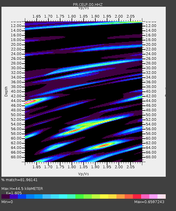
| Estimated Moho Depth: |
44.5 km |
| Estimated Crust Vp/Vs: |
1.61 |
| Assumed Crust Vp: |
5.14 km/s |
| Estimated Crust Vs: |
3.202 km/s |
| Estimated Crust Poisson's Ratio: |
0.18 |
|
| Radial Match: |
81.96141 % |
| Radial Bump: |
400 |
| Transverse Match: |
74.680626 % |
| Transverse Bump: |
400 |
| SOD ConfigId: |
24890451 |
| Insert Time: |
2021-06-02 18:19:20.590 +0000 |
| GWidth: |
2.5 |
| Max Bumps: |
400 |
| Tol: |
0.001 |
|

Signal To Noise
| Channel | StoN | STA | LTA |
| PR:CELP:00:HHZ:20210519T00:52:30.26997Z | 2.726983 | 5.774866E-7 | 2.1176758E-7 |
| PR:CELP:00:HH1:20210519T00:52:30.26997Z | 1.7324197 | 2.673812E-7 | 1.5433974E-7 |
| PR:CELP:00:HH2:20210519T00:52:30.26997Z | 1.5558031 | 2.6254824E-7 | 1.6875417E-7 |
| Arrivals |
| Ps | 5.4 SECOND |
| PpPs | 22 SECOND |
| PsPs/PpSs | 27 SECOND |


