You are here: Home > Network List > PY - PFO Array Stations List
> Station BPH01 Pinon Flat Observatory, CA, USA > Earthquake Result Viewer
BPH01 Pinon Flat Observatory, CA, USA - Earthquake Result Viewer
| Earthquake location: |
Southern East Pacific Rise |
| Earthquake latitude/longitude: |
-33.1/-109.4 |
| Earthquake time(UTC): |
2021/05/19 (139) 00:42:19 GMT |
| Earthquake Depth: |
10 km |
| Earthquake Magnitude: |
6.7 mww |
| Earthquake Catalog/Contributor: |
NEIC PDE/us |
|
| Network: |
PY PFO Array |
| Station: |
BPH01 Pinon Flat Observatory, CA, USA |
| Lat/Lon: |
33.61 N/116.46 W |
| Elevation: |
1292 m |
|
| Distance: |
66.7 deg |
| Az: |
353.585 deg |
| Baz: |
173.545 deg |
| Ray Param: |
0.057476483 |
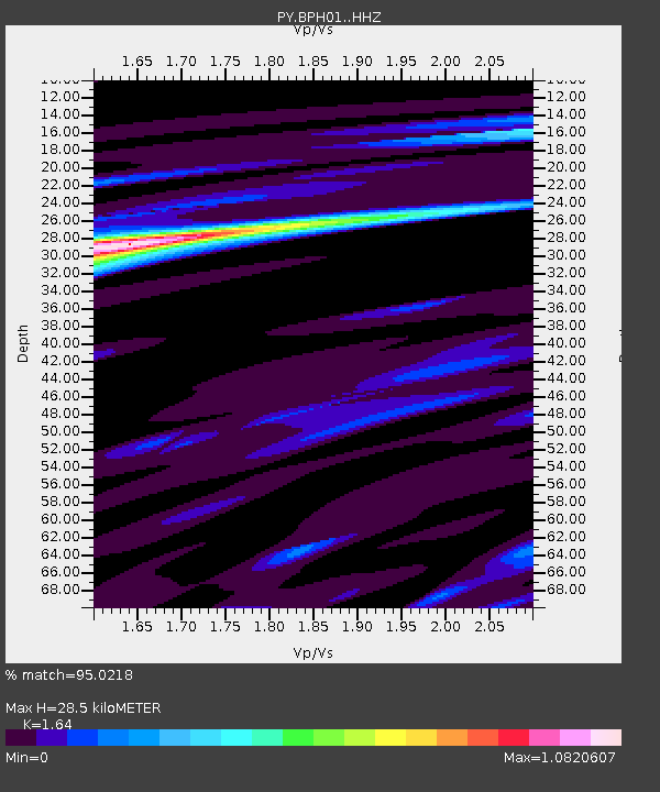
| Estimated Moho Depth: |
28.5 km |
| Estimated Crust Vp/Vs: |
1.64 |
| Assumed Crust Vp: |
6.264 km/s |
| Estimated Crust Vs: |
3.819 km/s |
| Estimated Crust Poisson's Ratio: |
0.20 |
|
| Radial Match: |
95.0218 % |
| Radial Bump: |
276 |
| Transverse Match: |
78.26326 % |
| Transverse Bump: |
400 |
| SOD ConfigId: |
24890451 |
| Insert Time: |
2021-06-02 18:19:40.716 +0000 |
| GWidth: |
2.5 |
| Max Bumps: |
400 |
| Tol: |
0.001 |
|

Signal To Noise
| Channel | StoN | STA | LTA |
| PY:BPH01: :HHZ:20210519T00:52:39.22102Z | 1.562531 | 2.4562343E-7 | 1.5719588E-7 |
| PY:BPH01: :HHN:20210519T00:52:39.22102Z | 1.9161402 | 1.7438228E-7 | 9.100705E-8 |
| PY:BPH01: :HHE:20210519T00:52:39.22102Z | 0.8331469 | 9.575646E-8 | 1.14933464E-7 |
| Arrivals |
| Ps | 3.0 SECOND |
| PpPs | 12 SECOND |
| PsPs/PpSs | 15 SECOND |


