You are here: Home > Network List > IU - Global Seismograph Network (GSN - IRIS/USGS) Stations List
> Station KMBO Kilima Mbogo, Kenya > Earthquake Result Viewer
KMBO Kilima Mbogo, Kenya - Earthquake Result Viewer
| Earthquake location: |
Northern And Central Iran |
| Earthquake latitude/longitude: |
30.7/57.3 |
| Earthquake time(UTC): |
2017/12/01 (335) 02:32:46 GMT |
| Earthquake Depth: |
9.0 km |
| Earthquake Magnitude: |
6.1 Mww |
| Earthquake Catalog/Contributor: |
NEIC PDE/us |
|
| Network: |
IU Global Seismograph Network (GSN - IRIS/USGS) |
| Station: |
KMBO Kilima Mbogo, Kenya |
| Lat/Lon: |
1.13 S/37.25 E |
| Elevation: |
1950 m |
|
| Distance: |
37.0 deg |
| Az: |
214.742 deg |
| Baz: |
29.389 deg |
| Ray Param: |
0.0763771 |
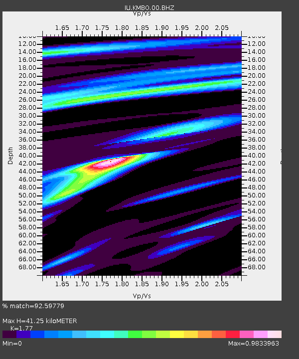
| Estimated Moho Depth: |
41.25 km |
| Estimated Crust Vp/Vs: |
1.77 |
| Assumed Crust Vp: |
6.601 km/s |
| Estimated Crust Vs: |
3.729 km/s |
| Estimated Crust Poisson's Ratio: |
0.27 |
|
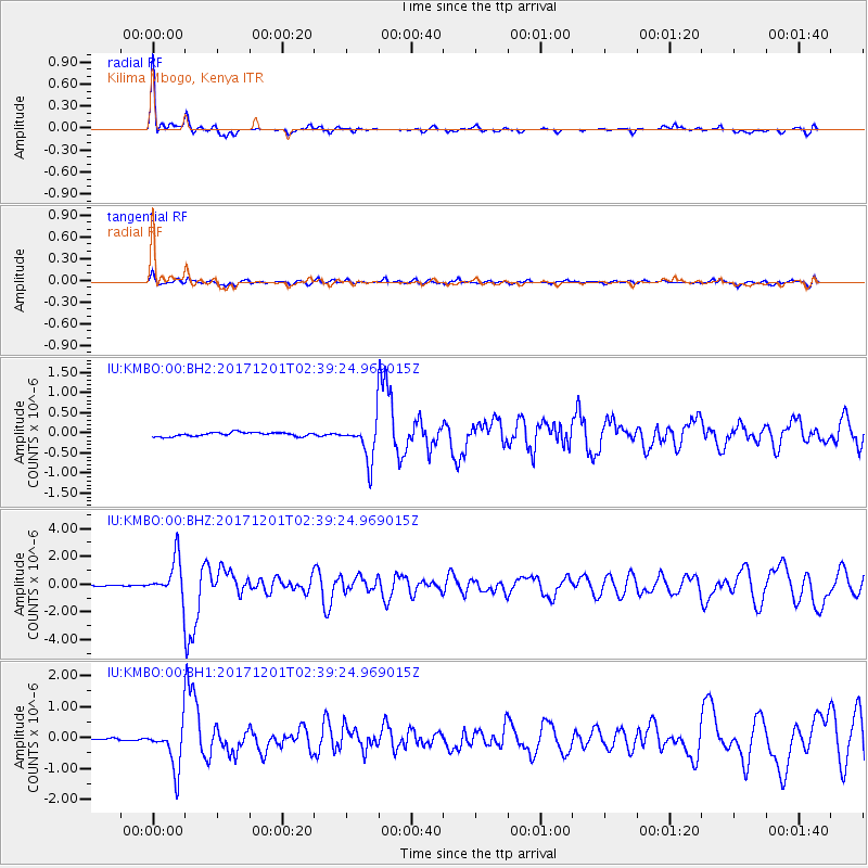
| Radial Match: |
92.59779 % |
| Radial Bump: |
297 |
| Transverse Match: |
73.71909 % |
| Transverse Bump: |
400 |
| SOD ConfigId: |
2429771 |
| Insert Time: |
2017-12-15 02:34:18.934 +0000 |
| GWidth: |
2.5 |
| Max Bumps: |
400 |
| Tol: |
0.001 |
|
Signal To Noise
| Channel | StoN | STA | LTA |
| IU:KMBO:00:BHZ:20171201T02:39:24.969015Z | 30.649954 | 1.4295725E-6 | 4.6641915E-8 |
| IU:KMBO:00:BH1:20171201T02:39:24.969015Z | 11.722492 | 7.231703E-7 | 6.169083E-8 |
| IU:KMBO:00:BH2:20171201T02:39:24.969015Z | 10.001308 | 4.841356E-7 | 4.8407234E-8 |
| Arrivals |
| Ps | 5.2 SECOND |
| PpPs | 16 SECOND |
| PsPs/PpSs | 21 SECOND |


